


Holding Back the Seas: Adapting to Sea Level Rise
Throughout history the world’s coastal cities were built and flourished during a period when global sea level has been near constant. However, during the last century tide gauge measurements and satellite altimetry suggest sea level has risen worldwide approximately 4.8-8.8 inches (12-22 cm) (IPCC, 2007). In addition, the international Arctic Monitoring and Assessment Program (AMAP) recently reported that Arctic glaciers and ice caps, including Greenland’s massive ice sheet, are shrinking faster than reported in 2007 by the IPCC. As a result, AMAP projects global sea levels to rise by 35 to 63 inches (90-160 centimeters) by 2100. Low-elevation areas are home to 634 million people, and two-thirds of the largest cities are partially located in coastal areas at risk from sea level rise. One out of every 10 people live in the low-elevation coastal zone, and the countries with the largest populations at risk include China, India, Bangladesh, Vietnam, Indonesia, Japan, Egypt, United States, Thailand and the Philippines.
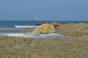
Photo by Robert Mickler | Beach nourishment to stabilize shoreline and protect coastal infrastructure.
Department of Defense (DoD) coastal and island installations are facing the same vulnerability to flooding and inundation as the world’s civilian population areas. Testing and training installations, ocean terminals, long-range radar sites, and Navy bases are all expected to experience significant changes to environmental resources, buildings and installation infrastructure. Future national security challenges have been recognized in recent legislation, which directs DoD to provide guidance to military planners to assess sea level rise risks and changes to world climate. The 2010 Quadrennial Defense Review placed a priority on understanding climate change effects on both DoD operations and fixed installations.
DoD’s Strategic Environmental Research and Development Program (SERDP, serdp.org) report, Climate Change Planning for Military Installations: Findings and Implications, states DoD policy makers, installation commanders and garrison staff consistently comment, “It’s all about sustaining the mission.” Each installation’s infrastructure, built environment and training lands are essential to support DoD’s testing and training, deployment and force readiness missions. Installation commanders understand that buildings, power grid, communication networks, transportation systems, sewage and storm water infrastructure, natural and cultural resources, and troop services require each of them to manage and to plan a small coastal city – a city vulnerable to future flooding and inundation, the risks of which continue to increase with rising sea level.
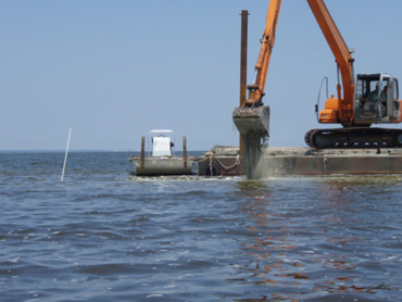
Photo by Aaron McCall, The Nature Conservancy | Rebuilding sustainable oyster reefs to stabilize shorelines and restore ecosystem services.
Planning for these risks is key to sustaining the mission, but installations are faced with keeping up with day-to-day requirements that often leave little time to consider climate change uncertainties in planning and management. Most installation commanders state that supporting and sustaining landscapes for training is their main mission, but few have the expertise to identify, analyze and use climate change information. Conflicting estimates of sea level rise rate and magnitude, and uncertainty associated with risk magnitude and timing voiced by faceless scientists at academic meetings also encourages confusion and complacency. However, even moderate sea level increase may result in disproportionate increases in flooding risk. Thus, a careful evaluation of potential consequences is worth making, especially for installations and municipalities in coastal areas.
Early climate change impacts can be effectively addressed through adaptation. However, options for successful adaptation diminish, and associated costs increase, with increasing climate change. At present, no certainty exists to the anticipated benefit or cost realized by adaptation, in part because effective adaptation measures are highly dependent on each installation’s geographical and climate risk factors, as well as institutional, political and financial constraints. It is useful to consider available adaptation options for military installations in coastal zones. Adaptation acts to reduce sea level rise impacts and severity, as well as frequency of storm events associated with climate change. Planning and implementation of adaptive management is necessary in the face of such large uncertainty about future climate. Therefore, any solution must to be viewed in a risk– and uncertainty-based manner, rather than looking for deterministic solutions. Given the importance of coastal and island installations to national security, autonomous adaptation processes are unlikely to be a sufficient response to sea level rise, as already shown for flood and ecosystem impacts in New Orleans and surrounding areas following Hurricane Katrina.
All government levels have a key role in developing planned adaptation measures. Planned adaptation options to sea level rise are usually presented as one of three generic approaches:
- Retreat – Barrier islands and coastal ecosystems are allowed to migrate, and human impacts are minimized by moving people and urban infrastructure back from the advancing coastline;
- Accommodation – Ecosystem processes, such as barrier island migration, inundation, erosion, and plant and animal migration, are allowed to occur, and human impacts are minimized by adjusting human use and coastal development;
- Shoreline Protection – Ecosystem services are restored and enhanced by creating natural defenses to sea level rise, including creation and protection of wetlands, restoration and protection of submerged aquatic vegetation and oyster reefs, restoration and protection of shorelines, stabilization of stream banks, creation and protection of riparian forest buffers, reforestation and beneficial use of dredged material for shoreline and habitat restoration, or by engineering methods to artificially hold back the sea.
The most reliable, sustainable and economical strategy for coastal facilities and communities is to plan well in advance and to adapt to the changing environment. A well-prepared facility or community, which is fortified to withstand flooding threats, will have an advantage over others that fail to plan. Successfully responding to impending change will require time to prepare and to take adaptive action. In many cases, the appropriate preemptive actions may take decades to fully implement. One of the most powerful tools for evaluating future consequences is computer simulation, which can be used to characterize a multitude of potential scenarios.
Sea level rise risk scenarios have been conducted with terrestrial and littoral models. The Sea Level Affecting Marshes Model (SLAMM) has been used to assess future changes in extent and composition of forest, shrub, fresh and brackish marshes, beaches, and inland, estuarine and open water. The model can be used to assist operations and natural resource managers in assessing at-risk infrastructure and natural resources and in planning and implementing adaptation strategies. SLAMM has been used at coastal DoD installations to assess risk at annual and decadal time steps from present to 2100. Within SLAMM, five primary processes affect coastal ecosystems’ fate under different sea level rise scenarios:
- Inundation – Water level rise and salt boundary are tracked by reducing elevations of each cell as sea levels rise, thus keeping mean tide level (MTL) constant at zero. Spatially variable effects of land subsidence or isostatic rebound are included in these elevation calculations.
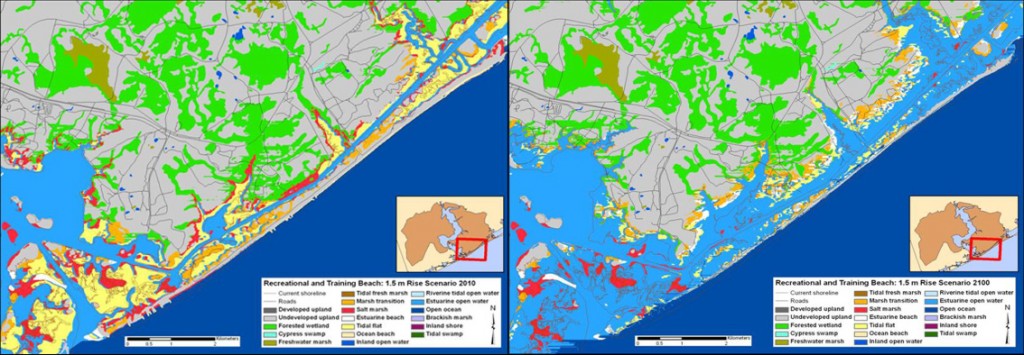
Click to View Larger Image – Credit: Robert Mickler, Alion Science and Technology, Inc. | 2010 and 2100 SLAMM simulations of sea level rise at Marine Corps Base Camp Lejeune Training Beach. Sea level rise will likely accelerate erosion of the beach, maritime forest and sand dunes that constitute the Base’s barrier islands.
- Erosion – Erosion is triggered based on a threshold of maximum fetch and proximity of the marsh to estuarine water or open ocean. When these conditions are met, horizontal erosion occurs at a rate based on site-specific data.
- Overwash – Barrier islands are assumed to undergo overwash at a user-specified interval. Beach migration and transport of sediments are calculated.
- Saturation – Coastal swamps and fresh marshes can migrate onto adjacent uplands as a fresh water table response to rising sea level close to the coast.
- Accretion – Sea level rise is offset by sedimentation and vertical accretion using average or site-specific values for each wetland category. Accretion rates may be spatially variable within a given model domain.

SLAMM is a dynamic vegetation model, which migrates and converts marsh and terrestrial ecosystems across the upland landscape in response to sea level rise and salinity changes.
An example of a diagnostic littoral model is the Advanced CIRCulation (ADCIRC) model, which can simulate hurricane induced storm surge and inland flooding. The ADCIRC computer model requires accurate descriptions of offshore, coastal and inland elevations, and details of frictional characteristics along the coast. Subject to these inputs to define the interest area, ADCIRC also accounts for all physical mechanisms that influence storm surge generation, such as wind and pressure forcing at the water surface, turbulent dissipation, Coriolis accelerations and astronomic tides. Subject to hurricane wind spatial variability and geometry and friction of the basin, ADCIRC will accurately compute water surface response. ADCIRC has been used for many years by U.S. Army Corps of Engineers (USACE) and Federal Emergency Management Agency (FEMA) to compute hurricane storm surge as part of flood mapping and design of flood protection projects.
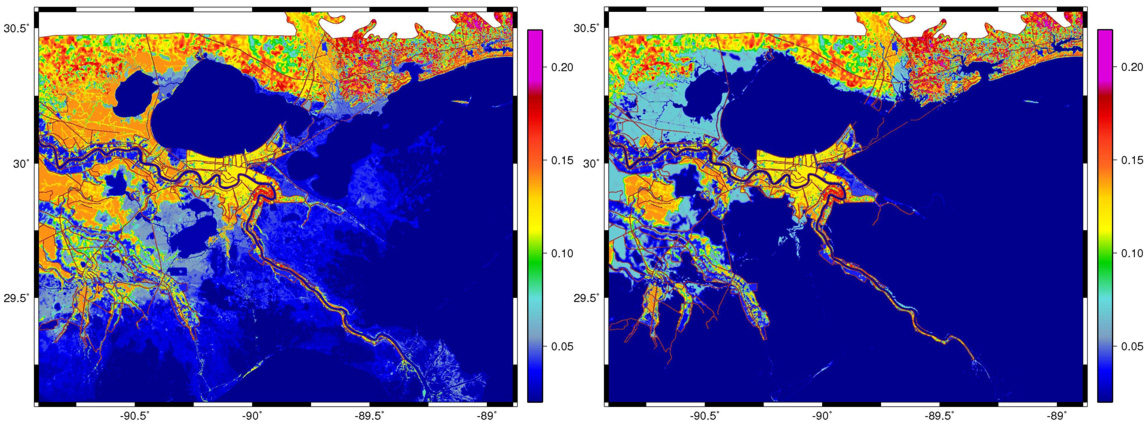
Click to View Larger Image – Credit: John Atkinson, Arcadis U.S., Inc. | ADCIRC model of present day southern Louisiana near Lake Ponchartrain, the City of New Orleans and the Mississippi River lower delta illustrates resistance to storm surge flow and flooding of urbanized areas. Higher Manning’s n values represent higher friction from vegetation and urbanization, thus greater resistance to storm surge and urban flooding. Under a 5 ft. sea level rise scenario in 2075, the ADCIRC model of southern Louisiana illustrates the combined effect of land subsidence and elevated sea level rise, which resulted in significant changes to the landscape since 2011. In particular, vast regions of wetland and marsh have been submerged, and changes to plant species and plant density have occurred even in areas not fully inundated. The result is less resistance to flow and greater potential for extreme storm flooding.
To evaluate potential future flooding due to a specific hurricane, ADCIRC inputs are modified to reflect future conditions and then storm simulations are repeated. In this manner, a wide range of potential future scenarios may be evaluated. Properly representing “future conditions” is more than simply increasing water depths to account for additional water volume in oceans. In addition to increasing water levels, many coastal regions are experiencing significant subsidence. Rising seas combined with lowering land can result in very large variations in Relative Sea Level Rise (RSLR) along the coast. Moreover, RSLR induces changes to vegetation at the coastal margin. As vegetation adjusts to changing salinity and water level, so too will the frictional resistance that vegetation has on flood waters. When vegetation is thick and healthy, flood levels can be partially attenuated. As marshes and other forms of coastal habitat retreat due to RSLR, flood waters can more easily penetrate inland. ADCIRC uses a Manning’s n formulation to account for frictional resistance. The loss of vegetation can add considerably to increased flood risk.

Click to View Larger Image – © Credit: John Atkinson, Arcadis U.S., Inc. | A map of hurricane flooding risk illustrates the Maximum Envelope of Water (MEOW) from many hurricane surge model simulations in southern Louisiana under present day conditions in 2011. The MEOW is useful in revealing areas of extreme flooding that may arise from possible hurricane scenarios. These simulations are based upon present day sea level and present day frictional characteristics.
As with sea level rise itself, morphological changes and vegetation changes occur slowly overtime. Models such as SLAMM and ADCIRC can be used to evaluate cumulative effect of these changes. Often, a future scenario is evaluated by simulating a representative set of hypothetical storm and hurricane events and deriving a statistical flood level for the scenario, or generating a Maximum Envelope Of Water (MEOW). MEOW indicates maximum flood at each location, which occurred during all simulations. An example MEOW is provided in the accompanying figures for which the region of interest is between New Orleans and Baton Rouge, Louisiana. Note that maximum flood levels are not simply 5 ft. higher than present day values. In fact, flood increase is as much as twice the RSLR amount. This behavior is in part a result of decreased vegetation and ability of deeper water to support larger waves, which bring energy further inland. Note also that flood level increase varies throughout the region. This suggests a complexity to predicting future conditions, which makes the use of computer simulation very valuable.

View Larger Image – © Credit: John Atkinson, Arcadis U.S., Inc. | A 2075 map of hurricane flooding risk illustrates the MEOW from the same set of hurricane storm conditions, but under a 5 ft. increase in sea level and the diminished frictional characteristics. A comparison of the 2011 and 2075 MEOW shows that maximum flooding potential has doubled the height of storm water surge in some areas.
One of the most powerful benefits of using computer models is to explore a range of likely scenarios in order to define limits of potential flood risks. Future RSLR forecasting contains significant uncertainty, and there are a range of RSLR rates suggested by the IPCC. The range of IPCC estimates are not associated with statistics to identify which RSLR scenario is most likely. In addition, storm events are drivers of extreme events, but much uncertainty exists in predictions of how storm frequency and magnitude will change as climate changes. Thus, while the increasing severity of a particular extreme event for a future SLR scenario can be demonstrated, it cannot be known if that event will also occur more often. Modeling is an ideal tool to wrestle with these uncertainties and should be used to identify and to prioritize the most vulnerable regions of coastline.
Planners are faced with a complacent public who readily dismiss sea level rise as irrelevant based upon conflicting and uncertain scenarios presented by the scientific community, and based upon the seemingly small annual rate of increase. However, sea level rise has more visible impact on extreme events than on daily events. Modeling reveals that extreme events are susceptible to increases much greater than just simple addition of the sea level rise amount. This is an important finding that planners and government agencies must communicate to the public. Despite uncertainties in climate forecasts, models can provide insight to the range of possible future risks, which can then be used to inform planning decisions and to build adaptive resiliency into new infrastructure development.
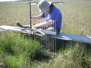
Photo by Carolyn Currin, NOAA | Protecting shorelines by monitoring increases in land elevation through increased soil accretion rates as a result
of increased productivity of marsh grasslands.
No individual Federal or state conservation program can address sea level adaptation and mitigation on the scale needed by individual installations or regional commands. One approach is to create innovative, actionable, multi-party implementation plans to address complex land use and ecological challenges on behalf of DoD. These would include developing landscape-scale, multi-stakeholder issue identification forums and solutions to climate change impacts on DoD installations. This could also include implementation strategies to acquire new training land to offset DoD land made unusable by sea level rise, to create off base conservation banks to replace critical habitat on base lost to climate change and to develop multi-party programs to acquire sea level rise buffers around DoD land. Other implementation strategies include using “natural defenses” to sea level rise, such as creation and protection of wetlands, restoration and protection of submerged aquatic vegetation and oyster reefs, restoration and protection of shorelines, stabilization of streambanks, creation and protection of riparian forest buffers, reforestation and beneficial use of dredged material for shoreline and habitat restoration. The goal is a comprehensive regional sea level rise management strategy to address impacts of critical habitat loss and low-level military training routes. This plan would provide installation commanders a range of implementation options and a set of recommendations on engaging appropriate stakeholders to achieve common objectives. The implementation phase of this sea level rise adaptation strategy is based on the premise that military operations must be protected from future sea level rise impacts. And, it will take a coordinated effort by military leaders, Federal, state and local agencies, and private conservation organizations to achieve this goal in a realistic, affordable, environmentally sensitive manner.
Division Manager, Alion Science and Technology Corporation
rmickler@alionscience.comGlobal Challenges