


The Strategic Implications of Sea Level Rise
The world’s oceans are rising and becoming one of today’s foremost national security challenges with strategic implications for the future. This acknowledgement is especially vital for U.S. military installation commanders as sea level rise during this century will exceed that of the previous 400 years, according to a consensus of the international scientific community. Throughout Earth’s history, the world’s seas have risen and fallen in response to global temperature changes and to continental glacier advances and retreats. For example, during the previous interglacial period 120,000 years ago, sea level was 20 feet higher than today. Conversely, while at the height of the last glaciations 18,000 years ago, oceans were 390 feet lower than today.
The 2007 Intergovernmental Panel on Climate Change (IPCC) sea level scenarios project a 7 to 23-inch rise by 2100. Some scientists consider this “conservative” as uncertainty in ice-sheet decay models may point to a more likely sea level rise in the range of 19 to 55 inches within this time period. Additionally, military planners should understand that seas will not rise uniformly throughout the world due to factors such as ocean circulation patterns, geologic subsidence, rebounding from the crushing weight of the last Ice Age glaciers, and land subsidence in response to massive oil and gas extraction along continental shelves.
Although scientists continually discuss sea level rise vulnerability and impacts, skepticism within U.S. military installations continues. Not surprising, this is primarily due to current controversy regarding observed 20th century sea level rise, coupled with the wide range of 21st century predictions. Operations and training managers would like projections for their installation to be associated with a specific probability of occurrence over specific decadal time periods. However, future sea level rise projections include uncertainty from continued ocean thermal expansion from global-scale warming as well as glacier, small ice sheet and continental ice sheet melting. The main cause of uncertainty prior to about 2050 is due to disagreement on processes that cause ice sheet melt and associated dramatic sea level rise increases. These include future amounts of atmospheric greenhouse gases, as well as the ability of models to predict the impact of increasing greenhouse gas concentrations. After 2050, the large variations in estimates are the result of warming rates tied to different projections of future greenhouse concentrations in conjunction with ice mass loss from Greenland and Antarctica – all of which are presently unknown.
Assessing Base Vulnerability
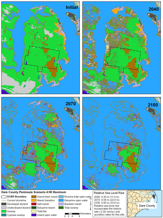
Sea level model projections by Robert Mickler and David Welch
In the U.S., scientists have identified coastal North Carolina as one of the most vulnerable regions to climate change. As a result, this area was the focus of a recent Department of Defense (DoD) Legacy Resource Management Program project on sea level risk to military installations. Co-authored by Alion Science and Technology’s Robert Mickler and David Welch, the study concluded that several installations are at serious risk from sea level rise inundation, erosion and saltwater intrusion. More than 2,000 square miles of North Carolina’s coastal ecosystems, which includes five military installations, are below 3-feet elevation. Projected sea level rise prior to 2100, along with increases in major storm severity and frequency, will impact coastal and island military and civilian infrastructure posing national security challenges from disruption of testing and training, and mission operations.
A summary of projections for coastal North Carolina indicates that DoD installations will experience varying degrees of risk based on actual sea level rise from present to 2100. These risks will vary even within an individual installation. North Carolina installations demonstrate the range of risk worldwide, which runs from severe to negligible.
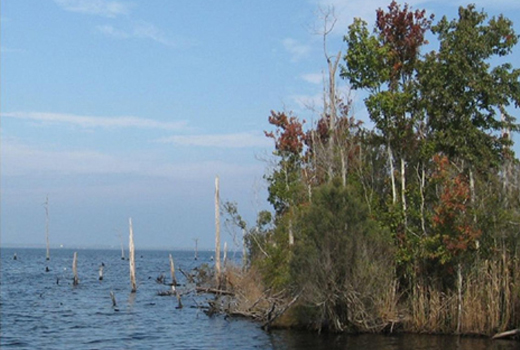
High Sea Level Risk – A close look at coastal North Carolina’s Air Force Dare County Bombing Range illustrates that sea level rise will radically alter land cover on the Dare County Peninsula, to include the bombing range.
Aerial photo by Dennis Stewart, USFWS
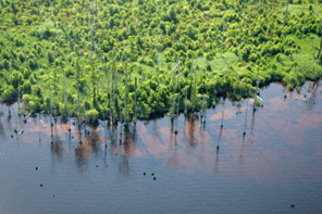
Geologically, this installation lies within the northern coastal province, a segment especially vulnerable to rising sea levels. The underlying geology of deep sediment (rather than shallow bedrock) contributes to faster rates of subsidence and higher shoreline erosion rates relative to other parts of the North Carolina coast. In addition, the elevation of the Dare County peninsula is quite low, with more than 80 percent under three feet. Sea level rise projections from the IPCC’s moderate A1B1 Max scenario provide for a 34-inch sea level rise by 2100, which will result in conversion of 40 percent of the installation’s land to estuarine open water. Equally important is the inundation of civilian infrastructure (roads, electric grid, communications and communities). In fact, the combined effects of sea level rise and land subsidence can be seen today on the inundated forests and marshes surrounding the installation. The shoreline is dotted with a standing dead forest, and forested wetlands can now be seen lying submerged in shallow waters.
Simulation results underscore installation and surrounding area vulnerability due to these low elevations throughout Dare County peninsula. Forested wetlands readily convert to wetter wetland types, such as salt marsh, marsh transition and brackish marsh. These marshes, in turn, transition to tidal flats and then open water 50 to 90 years into the model simulations. Even a moderate acceleration in sea level rise floods large parts of the peninsula by mid-century. Impacts will eliminate installation functionality due to poor access and flooding of base infrastructure. Other impacts will include degradation of rare flora and fauna habitat.
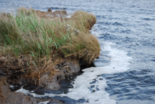
Photo by Robert Mickler
High and Low Sea Level Risk – The Marine Corps Air Station and Naval Aviation Depot Cherry Point is an example of a DoD installation with both high and low sea level rise risk. The bulk of MCAS Cherry Point’s main installation sits atop a bluff that fronts the Neuse River, thus effectively protecting it from impacts over the next century. Sea level rise inundation risk across all IPCC scenarios is limited to the floodplains in the installation’s stream network.
In contrast, Piney Island (BT-11), or Point of Marsh Target Area, is less than three feet in elevation. This facility is high risk to inundation and erosion from sea level rise. In fact, the area has been transitioning to wetter vegetation types, suggesting that it was once a forested wetland. The lack of tree regeneration and the predominance of marsh vegetation suggest that changing hydrology and increased salinity due to sea level rise or subsidence has allowed for the gradual transition from forested wetland to brackish marsh.
Flooding in the interior rather than on the fringes of the island will likely disrupt installation activities if sea level rise meets or exceeds two feet prior to 2100. Water inundation of large areas northwest of the airstrip and west of the target roads will compromise access to target areas and halt operations on the island prior to 2080. The BT-11 target area conforms to the highest risk of sea level rise among all North Carolina DoD installation facilities. Given the long-term viability of the main installation, MCAS Cherry Point would benefit from planning and acquisition of new adjoining target areas for testing and training operations.
Protecting Coastal Installations: Sea Level Rise Adaptation
Sea level rise simulations underscore the vulnerability of many DoD coastal and island installations in the U.S. and worldwide. Even moderate acceleration in sea level rise rates is projected to flood large parts of several North Carolina installations by mid-century. Impacts will eliminate installation functionality due to poor access and flooding of base and surrounding civilian infrastructure.
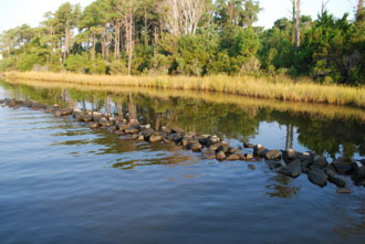
Photo by Robert Mickler
Future sea level rise risk could be reduced by managing natural processes by which wetlands build new soil elevation, and plant and animal communities migrate upslope to adapt to sea level rise. Or, they could be reduced by engineering methods to artificially hold back the sea. An installation’s mitigation strategy should first promote the natural processes by which wetlands trap sediments in the water column and build elevation. Other options include enhanced sedimentation application that mimics the vertical growth of marshes, and beach and sand replenishment on barrier islands used for amphibious training operations at installations such as Marine Corp Base Camp Lejeune.
Current North Carolina pilot-tested mitigation strategies include re-establishment of near shore oyster reefs and coastal marshes, planting of salt-tolerant trees, as well as construction of shoreline tide gates. Oyster reefs reduce shore erosion from storm surge and increase the rate of re-establishment of shoreline marshes. Salt-tolerant vegetation anchors soil and reduces erosion from wave action and major storm surge events. Tide gates act as one-way valves allowing fresh water from land to flow into the estuary while preventing saline estuary water from entering the land. Additionally, levees and pumping systems could manage surface waters and prevent inundation of coastal wetlands.
Encouraging a Paradigm Shift
State and county governments are beginning to seriously consider sea level rise risks to coastal communities. A similar cultural shift within DoD is required to transition mitigation planning and implementation into the hands of installation commanders. DoD installation climate change strategies and planning should be informed by the best available scientific information and sea level rise projections. Operational capabilities and infrastructure at risk will need to be assessed for each installation with commensurate mitigation strategies put in place. Responding to sea level rise will require careful consideration of cost/benefit analyses of protection or relocation of installation infrastructure, acquisition of new lands to replace those potentially given up to the rising sea and ecosystem management to enhance or re-establish coastal marsh productivity.
Regardless of which sea level rise estimates are most accurate, climate change will stress the U.S. military by affecting weapons systems and platforms, bases and military operations. The nature and rate of climate change observed today, as well as future consequences publicly debated by the international scientific community, are grave and pose challenges to U.S. national security, natural and cultural resources, and DoD installations’ capabilities and infrastructure. The consequences of climate change and sea level rise are clear – disruption of training, equipping and planning of military services. U.S. military sea level rise risk assessment must move beyond arguments of cause and effect and begin planning to address potentially devastating effects.

Global Challenges