


USACE Albuquerque District Returning Rivers to Their Natural Path
Think about it; rarely does a perfectly straight line occur in nature. When men bend or straighten elements of nature to suit human purposes, it can result in unforeseen circumstances. Throughout history, humans have intentionally influenced the path of rivers and waterways worldwide. The engineering term for this activity is “river engineering” – the process of planned human intervention in the course or flow of a river with the intention of producing a benefit, such as reduced flooding or easier passage. The science is known as “fluvial geomorphology” – the study of how rivers change their form over time. Many engineers and scientists in the U.S. Army Corps of Engineers (USACE) possess this engineering and scientific expertise. After all, the Corps often has the lead for devising hurricane and storm damage reduction infrastructure, like levees, to reduce negative impacts from disasters. While still involved in river engineering, today USACE has an increased emphasis on protecting and restoring the environment, which includes its monumental efforts in the Everglades, Louisiana Coast and along many of the Nation’s major waterways.
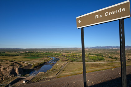
Employees in the Corps’ Albuquerque District engineered levees along the middle Rio Grande about 50 years ago after the River had been significantly channelized from development and irrigation works. Levees were created in response to historical instances of catastrophic flooding and loss of life, but they locked the River and kept it from finding its natural path. Before this work and the installation of dams at key positions upstream of Albuquerque, the Rio Grande would transport and deposit sediment as it meandered across the Rio Grande Valley, thus making the soil ripe for planting.
“Meanders are Nature’s way of slowing the flow of a creek, stream or river, which results in helping to protect the floodplain from erosion,” said District Hydraulic Engineer Steve Boberg. “Near Albuquerque, river engineering of the Rio Grande has created a perched river bed above the Valley floor and has hydrologically disconnected the River from the floodplain. If a significant flood were to occur, much of the water would not be able to return easily to the River’s channel.”
Boberg said rivers naturally meander as they take the path of least resistance, resulting in the river bed eventually obtaining an equilibrium slope. If a river runs into a large obstacle it will typically go around, versus through the obstacle, under normal flow conditions. As a river meanders, the velocity of the water is variable because the water towards the outside of a meander moves at a faster rate than the water on the inside of a meander. A river’s shape changes over time due to the different forces of the water and the obstructions the water encounters.
One result of channelizing and disconnecting the Rio Grande from the floodplain was increased urbanization and development. Another was the drying of fertile land to either side of the River and an increase in potential for fires. Yet another was loss of wildlife habitat contributing to increased hardship on endangered species, such as the Rio Grande silvery minnow and southwestern willow fly catcher.
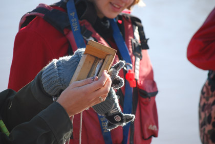
Photo Credit: U.S. Army Corps of Engineers|Measuring a Silvery Minnow
In response to these changes, the Albuquerque District and partner agencies are now involved in several Rio Grande restoration projects to find ways to reconnect the River’s active channel with the outer banks while keeping the levees.
“We have to remember why we did the river engineering in the first place,” Boberg said. “The levees were necessary to protect against severe flooding, and we have to make sure the restoration work does not reduce the effectiveness of these protections we have in place.”
At a cost of more than $20 million, the restoration work will include removal of invasive plants, seeding, planting, thinning, removal of jetty jacks (very large iron jacks positioned along the banks to catch debris), bank lowering and introducing high-flow channel braids. According to Boberg, channel braids are small, semi-circular channels that are excavated on alternating sides of a river to encourage slow river flow and to enhance wildlife habitat. Placement of the channels looks like a braid when viewed from above and helps return curves and meanders to the river during high flow.
Ecosystem restoration became a Corps mission in 1990 with a goal to restore degraded ecosystem structure, function and dynamic processes in its areas of operation to a less degraded, more natural condition. In 2002, the Corps reaffirmed its commitment to the environment by formalizing a set of “Environmental Operating Principles” that are applicable to all of its decision-making and programs. These principles foster unity of purpose on environmental issues, reflect a consistent tone and direction for dialogue on environmental matters and ensure that employees consider conservation, environmental preservation and restoration in all Corps activities.
For the past 10 years, the Albuquerque District has been a member of the Middle Rio Grande Endangered Species Collaborative Program, which has, in accordance with state and federal laws and Rio Grande compact obligations, promoted conservation and recovery of the Rio Grande silvery minnow and southwestern willow flycatcher. The program has contributed to Endangered Species Act (ESA) compliance for all program parties and has encouraged water development and management activities. All signatories of the collaborative program agree successful recovery of endangered species depends on each member’s cooperation to provide sufficient water and habitat to maintain viable populations.
Sufficient water is paramount, yet a challenge, in this arid climate because nearly every drop of water in the District’s operating area is closely accounted for via four water compacts. The four compacts are: Arkansas River Compact, Rio Grande Compact, Pecos River Compact and Canadian River Compact. In the old Southwest, a dam across a creek, shared with a neighbor, might produce a response with guns and dynamite. Today, a tight collaboration between several agencies driven by formal interstate compacts has eliminated water wars and protects a historic way of life for everyone along the major rivers in the Albuquerque District. The four water compacts were set up to “remove all causes of present and future controversy regarding the equitable distribution of waters” within those states.
Compacts ensure that each state gets its agreed share of the water and provides for mathematical reimbursements when a partner doesn’t. Typically, each compact administration has a set of “engineer advisors” to the compact commissioners. The engineer advisors meet prior to the formal compact meetings and invite various federal, state and local agencies to provide updates on ongoing compact activities and water operations in preparation for formal meetings. The Albuquerque District provides a report during the federal agency presentations portion of the formal compact meetings to explain Corps activities within the respective river basins.
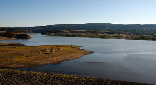
Photo Credit: U.S. Army Corps of Engineers|The U.S. Army Corps of Engineers built Cochiti Dam and Reservoir on the Rio Grande about 45 miles north of Albuquerque, N.M.
Corps lakes and dams in the Albuquerque District’s area of operations play a critical role in supplying water for communities and farms, preventing or reducing flooding and providing recreational opportunities for the public. However, the District does not own any of the water and, unless flood operations are occurring, typical water releases are based on downstream demands by stakeholders. Despite being the “middle-man” in the water purveyance business, the District’s personnel have sole authority to ensure flood and storm damage reduction infrastructure does not pose unacceptable risks to the public. During disaster, the District is ready to respond rapidly to provide emergency assistance.
According to the U.S. Geologic Survey (USGS), flooding is the most common, costly and deadly natural disaster in the United States each year. And, flash flooding is a real problem in the desert. Water doesn’t soak into dry, compact desert sand quickly, which means heavy rains tend to bring flood conditions with little to no warning. Remarkably, USGS confirms more people drown in the desert each year than die of thirst. Although emergency preparedness and response is primarily the responsibility of each state, USACE is authorized to assist communities in pre-flood preparations, during flooding and throughout a post-flood response. And, when disaster occurs, it is not just a local Corps district or office responding. Personnel and other resources are mobilized across the Corps’ 45 districts and nine divisions throughout the country to carry out response missions.
As an example of USACE disaster response, the Albuquerque District received an official request July 5, 2011, for technical assistance from Santa Clara Pueblo for anticipated flash flooding following New Mexico’s largest wildland fire in recorded history. The fire burned more than one-half of the Santa Clara Creek watershed, which is immediately upstream of the Pueblo. In response to this request, a small team formed and flood risk management authority and funds were identified to engage in assistance with initial flood risk scoping.
Two days later, on July 7, 2011, the Department of Energy, on behalf of Los Alamos National Laboratory, and the National Park Service, on behalf of Bandelier Monument, requested technical assistance for initially assessing potential flood hazards in their areas. Existing memorandums of agreement outlined protocols for USACE to provide flood risk management technical assistance to both agencies. Called into action for this assistance were District Supervisory Hydrologist Tamara Massong and Principle Hydraulic Engineer Bob Mussetter with a Corps contractor, Tetra Tech, Inc.
According to Massong, the fire began in the eastern, upper edge of the Jemez Mountains then traveled down the flanks of the mountains into several canyons. From there, the fire moved north along the mountains’ northern upper edge, across the headwaters of tributaries flowing into Los Alamos laboratory property and continued north into the headwaters of Santa Clara Creek. The fire spread onto the western flank of the mountains and entered the forests below. The reconnaissance team concluded that extremely hot fires had burned the canyons on the eastern and northern outer rim of the mountains, and these watersheds were at high risk for extreme flash flooding.
Santa Clara Pueblo and Bandelier Monument staff started generating emergency management plans, filling sand bags and building barrier walls to help protect buildings within floodplains impacted by the fire and now prone to flash flooding. Meanwhile, the Corps’ team continued to gather data and give technical assistance by identifying structures at risk for flooding.
© U.S. Army Corps of Engineers | When full, the Cochiti Reservoir can hold more than one-half million acre-feet of water that flows in from sources across more than 11,500 square miles. The five-mile-long dam towers 251 feet above the river and controls flooding and sedimentation.
For large rainfall events and their subsequent floods, the District advised the entities to be prepared to evacuate their floodplains. The District’s Flood Risk Management program also worked with others to install early warning systems in affected areas.
A major lesson learned from New Mexico’s Cerro Grande fire 12 years ago was that flood reduction structures installed after that fire had a high failure rate. Those that survived were designed with refined hydrology data that better predicted flood magnitudes. Data are gleaned from models and field collection considering the increased amount of runoff, water surface elevations, projected water velocities, potential debris flows and sediment transport on burned slopes. Massong said this information is critical to design lasting levees, dams or other flood reduction features.
In addition to providing technical assistance to assess flood risks and disaster response, the Corps provides permits and technical assistance to protect the Nation’s aquatic resources. As a matter of fact, the District was recently contacted to help with a situation that closely mirrored, although on a much smaller scale, the need for restoration work to re-curve and re-create habitat along the Rio Grande.
Approximately 50 years ago, about the same time the District used river engineering to design and construct the levees in Albuquerque, a creek “blew out” during a storm on a Colorado man’s property in the San Luis Valley, just south of Poncha Pass, and started to realign itself. At the time, the landowner saw an opportunity to straighten about a mile of the creek and intervened. However, in a few years the creek turned into a ditch and remained that way. The straightening removed two-thirds of the creek’s meandering, which sped up the water, causing the creek to become incised (cut downward) and lose all contact with the floodplain. The vegetation surrounding the creek had relied on the creek’s flooding, so it dried up on either side.
About two years ago, individuals from the Colorado Department of Parks and Wildlife conducted surveying and monitoring of Gunnison sage grouse in the landowner’s area, as the property is adjacent to state-owned land. The state employees witnessed the troubled creek and damaged grouse habitat and contacted the U.S. Fish and Wildlife Service (USWFS) and USDA Natural Resources Conservation Service (NRCS) to see if something could be done to restore the creek’s curves. They also approached the landowner to discuss programs that would cost-share the work and to explain why the work would result in improvements to his grazing areas. The federal agencies came to the Corps to ask for regulatory assistance. They knew a “dredge and fill” permit would be required from USACE to change the creek, as well as technical advice on the best way to do so.
“The Corps is responsible for implementing Section 404 of the Clean Water Act, which includes issuing dredge and fill permits in situations affecting ‘waters of the U.S.,’” said Regulatory Project Manager Hildreth “Coop” Cooper in the Albuquerque District’s Durango Regulatory Office. “I reviewed the plans to relocate the creek’s channel. They included forming two earthen embankments, re-excavating the old channel and re-establishing native vegetation. I made some modifications to avoid and to minimize impacts. For example, the plan called for creating a pond and excavating in wetlands adjacent to the creek, and it wasn’t necessary. It would amount to removing wetlands and valuable feeding habitat for the sage grouse.”
Obtaining permits for work of this kind is a legal requirement. The responsibility for enforcing this law fell to the Corps when Congress passed the Clean Water Act because it already had authority under the Rivers and Harbors Act to keep certain waterways navigable for commerce and national security. However, the U.S. Environmental Protection Agency retains ultimate oversight of the Clean Water Act.
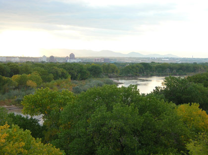
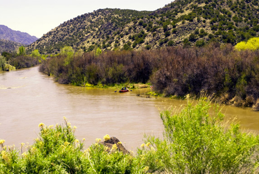
© U.S. Army Corps of Engineers | Rio Grande near downtown Albuquerque, N.M.
“Permits do not cost anything,” Cooper said. “NRCS applied for the permit in the landowner’s name, and this permit fell under a category of permits called ‘nationwide permits.’ They are relatively easy to obtain because the work results in minor negative impacts.” Most of the work on the creek took place in 2011, except for the restoration of a small amount of disturbed wetland area that was addressed in spring 2012. Also, due to last year’s drought, the replanting of the vegetative component of the project couldn’t be finished. Cooper said he has done one compliance inspection, but the ground was frozen and snow covered. He said he will go back in mid-summer to do another.
“I will look at the amount of bare ground that was created during the project because I want to make sure it gets replanted,” he said. “Also, I need to look at the best way to restore the small damage that was done to the wetlands. Monitoring is an important component of any stream restoration project. We will continue monitoring the vegetation and the response of the new channel and propose adjustments to ensure the stream continues to develop as designed.”
Ultimately, the project will help the landowner by allowing more moisture to reach his soil, and it will give him the ability to fence off areas and rotate his cattle, thus making for better herds. It will also enhance habitat for the sage grouse and various other wildlife. The USACE Regulatory Program is one of the oldest in the Federal Government. It is estimated that the program provides approval for approximately $220 billion in economic development, including critical transportation and energy infrastructure projects that create jobs.
All of the Corps’ myriad missions have one thread of commonality; they are conducted by people who are motivated to build and to cultivate a competent, disciplined and resilient team equipped to deliver high-quality solutions. Each district faces unique challenges based on its geographic area of responsibility, but the U.S. Army’s “Building Strong” motto means putting people first while working to solve local engineering challenges.
Global Challenges


