


Collaboration in Space: Global Maritime Awareness
According to the National Space Centre Ltd., satellites monitor the whole planet, but owners and operators don’t currently share information. That will change with a new cooperation initiative, C-SIGMA (Collaboration in Space for International Global Maritime Awareness), which has opened its headquarters at Elfordstown Earthsation, Cork, Ireland. C-SIGMA is an international initiative under which satellite owners and operators worldwide will share maritime-based information. The project aims to enhance maritime surveillance systems and to increase global effectiveness in areas like search and rescue, location and tracking of vessels, monitoring of beaches and ports, and detection of unlicensed fishing and illicit activity.
The C-SIGMA Centre will coordinate projects put forward by the C-SIGMA partners worldwide, and its location in Cork was approved at the C-SIGMA meeting in May 2012 at La Spezia, Italy. C-SIGMA partners include both public and private entities. And, participants in the inaugural C-SIGMA workshop, held at the European Space Agency headquarters in 2011 in Frascati, Italy, included the U.S., Irish, Italian, French and Japanese Coast Guards, Australian Customs, Italian, U.S. and Canadian Navies, EMSA, Frontex and NATO.
– George Guy Thomas
According to George Guy Thomas, former U.S. Navy, U.S. Air Force and recently retired U.S Coast Guard Science and Technology Advisor, “All maritime nations of the world have a stake in these topics, and many nations are working in just these concerns. But, no one nation can successfully counter all of these problems. Thus, a global consortium is required. The C-SIGMA Centre is dedicated to building that consortium with Elfordstown working to become its global information hub.”
Thomas, now president at C-SIGMA Consulting, has been involved in the creation of the C-SIGMA concept since its inception in 2004. He was the principal author of the maritime task within the Implementation Directive (ID) of Presidential Policy Directive 4, National Space Policy, June 28, 2010, (PPD-4) and both the Technical Exchange of Ais via Space (TEXAS) workshop series and the Collaboration in Space for International Global Maritime Awareness (C-SIGMA) international conferences.
Below is an outline by Thomas that explains the C-SIGMA Concept of Operations:
- Objective: Provide global, persistent surveillance and maritime situation awareness of the world’s maritime environment via an internationally available structure using unclassified civil and commercial space systems, thus fostering international collaboration to:
- A. Enhance global maritime domain situation awareness,
- B. Provide enhanced safety of life at sea,
- C. Increase mutual security of all users of the maritime domain,
- D. Improve protection of the maritime environment and the sea’s resources,
- E. Improve flow of commerce and
- F. Better monitor the condition and performance of the Marine Transportation System.
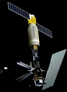
Courtesy of NASA GSFC|Seasat was the first satellite designed for remote sensing of the Earth’s oceans with synthetic aperture radar.
- Problem Statement: Maritime surveillance is provided by four different types of unclassified commercial and civil satellites. No one country operates enough of these satellites and their associated ground stations to provide pervasive ocean surveillance. Thus, collaboration on a broad scale is required to provide global maritime situation awareness.
- Systems:
- Two of the four basic types of space-based systems that need to be used in conjunction with each other to achieve the stated goal use imaging sensors:
- Synthetic Aperture Radar Satellites (SARSats) (day/night, clear/cloudy collection) – approximately 11 currently in orbit (Canada, Italy, Germany, Japan, India),
- Electro Optical (EO) imaging satellites (day/clear, but very high resolution) – approximately 70 currently in orbit in varying degrees of resolution – six (?) high resolution (United States, Germany, France plus others).
- The other two are based on communications systems:
- Individual Transponders linked to Communications Satellite (e. g. Iridium, ORBCOMM, INMARSAT, etc.) – too numerous to list,
- Automatic Identification Systems (AIS) – a system originally designed for collision avoidance and safety of navigation but more and more coming to be used as a primary ship tracking system. This is especially true of satellite based AIS (S-AIS). Approximately 11 are currently in orbit with 25+ more coming in the near future (United States, Canada, Norway, Japan, India, Germany plus other countries).
- Two of the four basic types of space-based systems that need to be used in conjunction with each other to achieve the stated goal use imaging sensors:
- Systems Employment: The above systems will be employed in the following manner:
- S-AIS and such self-reporting systems as Long Range Identification and Tracking (LRIT) and IMARSAT polling, plus the self-reporting systems most commercial shipping industry companies use to track their assets1, would be used to allow authorities to understand where law abiding vessels are located and their operational patterns in order to define what is normal. These systems set the baseline for subsequent analysis. Proactively imaging areas of potential interest by SARsats to establish operational norms, to expand the baseline of operational information beyond what S-AIS and LRIT provide, to compare with what is happening immediately before and after an incident is reported is also necessary. This is especially true of pollution and Search and Rescue events. Who was where and when are often critical pieces of information.
- Immediately after an event is detected EO and, especially, SAR would be used to detect all activity in the area of interest, such as where a ship was last attacked or where pollution has been detected or a ship reported in distress or potential smuggling has been noted, with time/distance circles out from the area of last known activity – the “flaming datum” of anti-submarine warfare.“. . . it is the location of the uplink and downlink terminals that often determine responsiveness of the satellites . . .”
- The two data sets will be compared using dynamic analysis tools, such as what CLS, e-GEOS, KSAT, Windward and others have developed, to help both refine the search area and give indications about which contact might be a vessel of interest (polluter, smuggler, pirate mother ship, ship distress, missing ship, etc.) in images gathered in the search area.
- Getting “eyes on target” in a tactically significant time frame is critical as the longer the delay the larger the search area. Location of uplink terminals for tasking and downlink terminals2 to receive data collected, and connectivity of both to decision-makers and connectivity of decision-makers to action takers is critical.
- As terrestrial interdiction/assistance systems (ships/aircraft) are vectored toward contacts of interest, space assets would continue to be tasked to study the area, especially employing high-resolution EO systems and SARs in high-resolution modes in an effort to more clearly define who the real target is and what is actually happening. Updates would be passed to the interdicting tactical units until the event is terminated.
- Conclusion: Each space system clearly plays a unique role, but the operational problem is compounded because no one country has sufficient numbers of satellites and their associated ground stations to provide an efficient ocean surveillance system. Indeed, in that nearly all earth observation satellites are in low earth orbit3 , it is the location of the uplink and downlink terminals that often determine responsiveness of the satellites themselves. Given that maritime situational awareness is a global necessity, requiring a global presence – the ability to up- and down-link on a global scale – is required to create a global system that permits response in a tactically useful time frame. For that reason alone, international collaboration must take place for the proposed global maritime surveillance system to work most effectively.
Global Challenges


