Katrina and the IPET: Understanding the Truth Behind the Tragedy
Hurricane Katrina will be remembered as an unparalleled national disaster not only because, according to the National Oceanic and Atmospheric Administration (NOAA), it became America’s “most expensive natural disaster in U.S. history ($133.8 billion in damage/costs) with the highest death toll since 1928 (approximately 1,833 deaths),” but also because of New Orleans’ unforeseen destruction, the resultant blame game and media sensationalism. The event’s reported media inaccuracies, which have perpetuated the heartbreak of a nation, continue to prevent many people from understanding the truth behind the tragedy. It’s difficult to know whether the ongoing misinformation flow was a by-product of power plays, political agendas or poor judgment. Maybe it was, more innocently, a consequence of the American public’s need to lay blame on someone or on some agency in hopes of feeling safe again. After all, how could all of this have happened in America? Fortunately, it’s possible to comprehend after reading the final volumes of the Interagency Performance Evaluation Task Force (IPET) Report, issued June 2008.
Now retired Lieutenant General Carl A. Strock, U.S. Army Corps of Engineers’ (USACE) Commander, along with Major General Don T. Riley, then USACE Director of Civil Works, and Donald Basham, now retired Chief, Engineering and Construction, Directorate of Civil Works, USACE, collaborated to create a mechanism that would, according to Strock, “ . . . provide credible and objective scientific and engineering answers to fundamental questions about the performance of the hurricane protection system and flood damage reduction system in the New Orleans metropolitan area.” On Oct. 10, 2005, Strock officially announced the IPET and named Dr. Lewis E. (Ed) Link, a member of the Civil and Environmental Engineering faculty at the University of Maryland in College Park, its Director.
“I’ve had absolute complete freedom to do what I felt was in the best interest of the public; and, I think, that was one reason why I didn’t mind what started as a 9-month assignment becoming an almost 3-year endeavor. It’s been gratifying to work on something of this magnitude and importance with so many people that are just incredibly dedicated to doing what’s right. And, that’s been astounding,” commented Link as he was getting ready to put his ink on the final report.
IPET and Its Unique Dimensions

© U.S. Navy photo
IPET continues to be more than a groundbreaking forensic study of Katrina-related events. The task force began as an investigation team with a dual mission: First, they had to find out what happened to structures that comprised the Hurricane Protection System (HPS) and why it happened so that repairs and rebuilding would not reintroduce any vulnerability into the system. Second, the team put that knowledge into the ongoing repair work that was scheduled for completion before the next hurricane season following Katrina (June 1, 2006) and into building a foundation for developing stronger and higher levels of protection in the future. The task force wrapped up its work with an emergence of knowledge that is revolutionizing engineering as it incorporates ideas of “risk,” “risk reduction” and “risk mitigation” into all aspects of practice and education, particularly for the Corps.
“We began with what the analysis should look like, what the major pieces would be . . . then we decided on an architecture that became the 10 teams that were involved in the IPET. We knew we had to take advantage of the best knowledge and expertise that existed within the Corps, but we also needed to create an environment of objectivity and openness. We solved that by selecting co-leaders of each of the 10 teams so that each team had an external leader, like Dr. Mike Duncan from Virginia Tech, who is a nationally renowned geotechnical engineer, and a USACE leader, like the Corps’ Dr. Reed Mosher, for the structural analysis. Mike and Reed were the co-leads for the performance analysis. Each team concentrated on a unique aspect of the analysis. We ended up with well over 300 people involved in the IPET . . . and likely more than half were from industry and academia. In addition, the credibility of what we did was clear and open: We set up a public web page (https://ipet.wes.army.mil) on day one and posted our plans on the web site. At the same time, under Department of Defense and Corps direction, independent peer review panels of national experts were set up by the American Society of Civil Engineers (ASCE) and the National Research Council (NRC). And, we continued throughout the whole process to put whatever reliable information we had on the public website for everyone to use and to see. Each time we held a meeting with the ASCE or NRC panels, it was a public meeting and we had media involved,” explained Link as he described the IPET’s formation.
With this level of openness, transparency and objectivity, Link and other IPET team members were disappointed by much of what was portrayed in the mainstream media. “I think there were a lot of inaccuracies with what the media presented. Some of it was headed toward the spectacular. There were a lot of people looking for villains and many, as you would expect, who were very bitter and very angry with what happened in New Orleans; that certainly is understandable. The trade press seemed to be more aware of the nuts and bolts of natural disasters so there tended to be less sensationalism in their reporting. The daily media, however, had a tough time with it. I think part of it was that Katrina was such a complex issue, and people were outraged,” recalled Link.
Unraveling a Complex Environment
© U.S. Navy photo
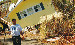
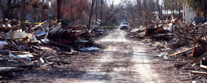
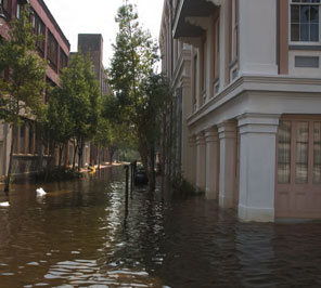
When the IPET team first appeared in New Orleans, they were staggered to see the level of flooding and destruction that had occurred in both economic and human terms. From the beginning, it was clear that there were unexpected dimensions to the Katrina tragedy. According to Link, “This wasn’t a small storm; this was much more complex than what was being portrayed initially in the media. In addition, the size of the HPS — 350 miles of structures, all the pump stations, hundreds of other features like transitions from one kind of structure to another, and all the gates and closures that occur in these structures to allow water in and out — pointed to the complexity of the problem and the complexity of trying to unravel it, to decode it and to figure out exactly what did happen.”
With this level of intricacy, it was obvious that every one of the teams’ efforts would require considerable time to produce final outcomes. But they couldn’t wait. So they devised a system whereby all 10 teams could work simultaneously even though each team’s data was critical to another team’s analysis. Link said groups achieved the amazing task by “iterating our way through this process. For example, every team would move forward and make the best estimate it could regarding the kinds of information on which team members were working. We’d go through the entire analysis up to a point by using the best data we had available, integrate the information and see where we were with regard to useful results. Then everybody would move forward another step. Then we would go through the entire analysis again so we kept iterating our way, all 10 teams, individually but together. The ASCE External Review Panel played a major role in our being able to impact repairs. They continuously reviewed IPET plans, processes, interim results and interim findings to provide confidence in transitioning findings to the Task Force Guardian folks who were engaged in the repair process. In fact, we had 20 people from Task Force Guardian embedded in the IPET teams so that when they saw info that was critical to their repairs, they would just grab it and run.”
Uncovering the Causes of Flooding
© iStockphoto.com/ParkerDeen
The major flooding component in New Orleans, according to Link and the IPET, was the overtopping of earth levees, which caused substantial breaching. And the breaching occurred because, in some cases, the surge and wave environment created water levels of 5-10 feet cascading over the levees as water eroded them from the back, not the front, side. The biggest engineering problem related to flooding was the frailty or fragility of the I-walls (floodwalls). In four of the breaches — one on the 17th Street Canal, two on the London Ave. Canal and one adjacent to the Lower 9th Ward on the Inner Harbor Navigation Canal — the I-walls failed before the water reached an elevation considered to be their design elevation (the water did not overtop the walls). In other words, they failed prior to when they should have and did so because of a design flaw that caused a deflection in the wall that allowed high water pressure to get into the system’s foundation. The four I-wall failures were responsible for a large amount of water that flooded New Orleans neighborhoods and the Lower 9th, but the other 50 floodwall breaches (54 in all, 4 related to design flaws) were caused by overtopping. Of the 350 linear miles of HPS structures, the Corps eventually repaired and improved 220 miles of levees and floodwalls.
The original HPS design and the large amount of overtopping are integrally related. Based on the best available science and the accepted process in 1965, the Corps developed the original design criteria. Unfortunately, climatology changed dramatically from that time until the 1970s, when NOAA upgraded the hurricane threat. With this revised information in hand, Link explained, the Corps decided that it could not afford to “go back and redo everything that was being put in place based on this new hurricane threat.” (Please refer to the USACE Hurricane Protection Decision Chronology report titled Decision-Making Chronology for the Lake Pontchartrain & Vicinity Hurricane Protection Project, Final Report March 2008 for more information.) “Part of this decision was because the funding and authorization ‘system’ doesn’t react well to change. In other words, there was no Congressional authorization to spend money on raising levees to deal with this more severe hurricane threat. I think the Corps’ rationale was that it was better to have something than to have nothing. The idea was to move forward and to build something — what they had designed and approved already, and then seek approval to build higher levees — rather than to stop the presses and wait to see what happened.”
The other big issue was the structures’ height. The Corps became aware in the 1980s of a local elevation data error, which caused some structures to be built 2 feet too low. The Hurricane Protection Decision Chronology report addressed this issue, but Link has explained in easy-to-understand terms that “you don’t just go add 2 more feet to the top of a floodwall. So, that was another big controversial issue. Now we have a more severe hurricane threat that wasn’t dealt with and errors in elevations that aren’t dealt with — that were deliberately not dealt with — because the decision was made to go forward and to put a complete system in place and then go back and fix it.”
Another major issue was and continues to be the area’s significant subsidence because of natural processes and land use decisions. “When you build on organic soils and you drain organic soils and you pump a lot of groundwater out from under an area like New Orleans, it’s going to sink. Many areas within the city that are now well below sea level used to be marshes that were approximately at sea level or above. But the development of the land and the pumping of the groundwater from underneath the city to keep it dry have caused these areas to subside. Along with the general landscape subsiding, the levees have subsided too. Everything is moving down. Maps published in the IPET report show that, as a direct result of this subsidence, some structures are more than 2 feet below their authorized elevations. Pumping of groundwater and development of swamps is not a natural process. The whole region is subsiding somewhere between 1/2 –1 foot per century, but this man-induced subsidence — that’s in addition to the regional subsidence — has been much more rapid than that. When you add everything up, you end up with a big disaster,” explained Link.
Another unexpected, significant factor in 2005 was Katrina’s massive size. “Perhaps the most egregious misconception in the media was that Katrina was a small storm. This was unfortunate because it really led people down the wrong path, and they didn’t understand the challenge that Katrina presented. On the eastern side of New Orleans, Katrina created a surge and wave environment that was greater than anything North America has seen before (28-foot storm surge; 55-foot waves). It was huge. The problem is that the Saffir-Simpson Scale (normally used in weather forecasting to ‘categorize’ a storm) is a very poor estimator of surge. It’s the combination of the intensity and the physical size of the storm that generates surge. And that was one of the major findings from this analysis. There’s a National Academy of Sciences committee in place right now trying to decide exactly how we can better estimate the intensity or the severity of hurricanes,” Link said.
Dealing with Dynamic Changes

© iStockphoto.com/joeynick
Back in 1965, when the HPS was originally designed, engineers thought they knew what the hurricane threat was, and they used the best science available. “Now we look back 50 some years and say ‘boy, you guys really got it wrong’; but it wasn’t because they were dummies. They didn’t have the advantage of the updated understanding of hurricane climate and so on. You learn something new all the time. For example, we learned that NOAA put out revised information on the more severe hurricane threat. Then the error was found in the elevation datum; and, probably with the new technologies, the amount of subsidence, the degree of subsidence and the condition of the structures could have been better estimated than back 50 years ago.”
“But the real problem is how to deal with the current way that water projects are authorized, funded and operated. The system is not very agile, and it’s very difficult to deal with dynamic things that can cause major changes. What’s more challenging is getting the money to make those necessary changes. When you look at the funding history of projects for the New Orleans HPS, the last couple of decades have not seen a lot of resources poured into that compared to what the original needs were. Some of that was cost escalation, inflation and so on; but the Hurricane Protection Decision Chronology report shows that actual cost was a huge factor in what the system ended up looking like. Local entities were charged with paying 30 percent cost share, and part of their challenge was trying to figure out where to get that money. That became an issue with regard to the ultimate design and the ultimate footprint of the HPS that got put in place,” explained Link.
Yet another serious issue is people misunderstanding nomenclature. For instance, a “100-year storm” does not mean that a storm of a given magnitude will occur only once within 100 years. It means that such an event has one chance in four of occurring within a 30-year mortgage or a 1 percent chance of occurring each and every year. With respect to one’s understanding of “100-year protection,” the meaning is the same. Homeowners need to realize that they have one chance in four that their house will be flooded within the life of their 30-year mortgage. These odds are not good, particularly when lives are at stake. This same event over 78 years (the average U.S. lifespan) has a 54 percent chance of occurring. Over 100 years, it has a 63 percent chance of occurring. “If you had this kind of chance of being killed in a car, you wouldn’t get in a car,” Link added.
The Corps is currently authorized by Congress to achieve 100-year protection in rebuilding the HPS, at a total investment of more than $15 billion, and is conservatively adding in the potential impacts of climate change, sea level rise, subsidence and more severe storms to afford an extra degree of protection into the system. The Louisiana Coastal Protection and Restoration Study (LACPR), a Corps project in partnership with the state of Louisiana, is looking at reasonable ways to provide even higher levels of protection in the future. According to Link, “The ideal would be to have the wetlands and levees working together. That’s not always possible, but it would be the ideal. If we’re going to achieve higher levels of protection in a practical manner, it’s going to have to be through some combination of natural environment and physical structures.”
© iStockphoto.com/joeynick
When the 100-year structures (scheduled for completion in 2011) are in place, New Orleans will have the best actual physical risk reduction measures it has ever had. Yet, it will still be vulnerable to flooding by very large storms. Bottom line: This city will be the only one in the nation that has a rigorous assessment of its risk. That huge advantage will allow much smarter decisions to be made for redevelopment and recovery as well as for better managing hurricane risk in the future. Methods developed for New Orleans are applicable anywhere and need to be evolved and improved to provide effective decision support tools for protection of other people and other cities,” explained Link.
“IPET findings and lessons are based on the experience of a past event, Katrina, but they are an important lens into the future. We too often optimize based on immediate cost and accept short-term gains instead of long-term solutions. This is a national cultural malady that can only be reversed if the public demands a change in policy. There’s a whole new body of knowledge as a result of the IPET findings that we’ve just begun to apply now, and we’ve got to continue to apply it, to learn and to grow from it. That’s really critical so we have to keep the momentum going. We can’t let it relax,” declared Link, who looks forward to a better and safer America — thanks to his IPET team members.
Related Files:

