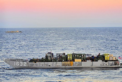
 U.S. Navy photo by Mass Communication Specialist Seaman Anna Wade | Suspected pirates indicate their surrender with a white cloth on the Japanese-owned commercial oil tanker M/V Guanabara.


Space-Based Ocean Environmental Protection & Global Maritime Awareness
In the past few years a revolution has occurred in space-based Earth observation systems and, led by the space-based Automatic Identification System (AIS), their utility throughout the world’s waterways has increased dramatically. These capabilities not only increase safety and security but also significantly assist economic and environmental stewardship. Potential contributions of space-based Earth observation systems to all facets of global maritime awareness are of growing interest. This includes naval and law enforcement forces, environmental preservationists, ship operators and brokers, as well as others in the maritime industry. Much of this increased utility can be attributed to S-AIS (Satellite-AIS), but it is not alone. Just as GPS was originally designed to assist in improving accuracy of U.S submarine-launched ballistic missiles (but has now become ubiquitous), space-based AIS was conceived as an anti-terrorism tool. However, as the system evolved so has the thinking regarding its wide range of uses. Although it’s only one tool needed for global maritime awareness, it’s the enabler for the rest of the set.
But, more than just tools are needed. Indeed, it is widely recognized that no one country has the stature, breadth and depth to protect the world’s oceanic environment, commerce and finite resources of the seas, especially its fish and oil. It will take international collaboration and cooperation on a nearly unparalleled scale to assure the safe, secure and equitable use of Earth’s oceans. This effort, while simple in concept, has such a range of entities and interests involved that it may need to be managed by an agency of the United Nations. The core need, as well as the greatest opportunities for international collaboration, is to focus on the technology required to detect, identify and track vessels offshore. That technology exists today, but it is scattered among a range of nations with little coordination in its use. The one exception is several successful demonstrations within the past five years to examine the feasibility of global maritime awareness from space.
 One primary step nations could take is the creation of a global space partnership (GSP) initially focused on the maritime domain. This concept has been informally discussed for some time by many people, especially those in countries with large, exposed shorelines, such as Canada, Norway, Japan and Italy. It has also been discussed by those with a history of environmental damage caused by intentional or unintentional dumping of oil, like Ireland. The maritime focused portion of GSP is called “Collaboration in Space for International Global Maritime Awareness (C-SIGMA)”. It is certainly recognized that GSP would have much broader capabilities than just the maritime domain. However, many recognize the critical vulnerabilities of the world’s maritime assets and the huge economic impact their loss could generate, thus the pressing need for better awareness of the global maritime domain.
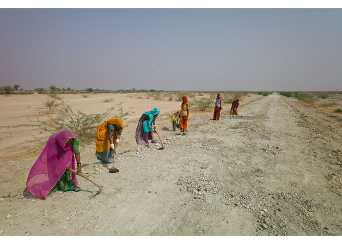
Increased awareness starts with better ocean and coastal surveillance – points borne out twice recently. First is the recent widespread recognition that piracy is alive and well in the 21st Century and is a growing, not diminishing, threat. Second is the terrible November 2008 attack on Mumbai, India’s largest city, when 10 of 11 attackers came ashore in inflatable speedboats. Needless to say, such events bring attention to the need for better maritime awareness. Many practitioners and researchers have come to believe that unclassified space systems play a crucial role in any effective maritime awareness system. However, space systems cannot do it all. Collaboration and coordination with terrestrial systems as well as mining and analysis of data contained in hundreds, if not thousands, of databases is also needed. Likewise, it is recognized that coordination is needed all the way down to responding tactical units. However, those are wholly different issues that will not be addressed here, except to be acknowledged.
Oil may be the world’s lifeblood, but oceanic commerce is its backbone, if not the entire skeleton. While the Sept. 11, 2001, attack on the United States did not have a maritime component, it did serve as a wake-up call in many venues, not just within the U.S. World maritime entities – military, civil and private – evaluated their situation in the new reality and quickly understood the vulnerabilities and potential consequences. Since then, a number of national and international organizations have addressed how to protect maritime assets, both individually and, in growing numbers, collectively. Most saw increased maritime domain awareness (MDA) as a critical component of the smooth functioning of commerce on the world’s oceans, the crucial supporting frame of the world’s economy. Added to the threats of piracy and sea-borne attacks is the growing realization that misuse and mistreatment of oceans is causing significant environmental damage. Coupled with oil and fish theft, this is leading to substantial loss of economic resources. Therefore, a wide variety of organizations either have or are developing systems and concepts of operations (ConOps) to deal with regional, if not global, maritime awareness.
Thus, the potential, unique contributions of current and planned commercial space systems from a wide range of nations to international maritime awareness is a subject of growing interest to many. No one country has the stature, breadth and depth to successfully organize a meaningful coalition to protect oceanic commerce, the maritime environment and the broad range of individuals who use the maritime domain for a multitude of endeavors, including profit, conveyance and recreation. The only organization that has addressed a task similar in scope is the International Civil Aviation Organization (ICAO), which works to ensure smooth and safe functioning of the civilian aviation industry. And, that effort took almost 40 years to reach full functionality after the need was first articulated in 1909. Because the maritime domain has been an integral part of the world’s commerce and conveyance systems for thousands of years, it may be much harder to create the needed organization to regulate it.
U.S. Navy photo by Mass Communication Specialist Seaman Anna Wade | Suspected pirates indicate their surrender with a white cloth on the Japanese-owned commercial oil tanker M/V Guanabara.
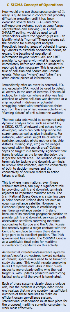
The political aspects of forging that type collaboration are the real challenge. Still, a tangible goal, working towards both technical and policy aspects, will assist in focusing political and policy discussions. Building C-SIGMA is one such attainable goal. The two critical segments of that universal awareness are shared surveillance assets and a universal common operational picture (COP). Many are already working the COP issue with such programs as Cooperative Nations Information Exchange System (CNIES), Virtual Regional Maritime Tracking Center-Automated (VRMTC-A), Regional Maritime Awareness Capability (RMAC) and the Maritime Safety and Security Information System (MSSIS). Fewer are looking at the front end of the chain – the sensor end. One needs to look at both in balance. This article tries to restore that balance by focusing on the why and how of developing required surveillance assets.
Most maritime concepts of operations assume some form of layered zones of surveillance and defense from well offshore to point defense of high-value targets within ports and adjacent waterways. Generally, more zones exist between those two zones, including approaches and coastal zones. The end game – protection of high value targets – is a major goal. Those high-value targets include not just significant ships but also port infrastructure or other targets of high economic, political or military value. These include power plants, sewage treatment facilities, chemical plants, critical bridges, historic monuments and the like. This greatly compounds the problem, but every bit of defense helps. Early warning is critical. However, the heretofore emphasis on port surveillance systems indicates many do not understand the criticality of early warning and the need for it to begin far offshore, if not actually with the surveillance of supporting shore infrastructure across the seas. For illegal acts committed on the high seas, such as oil dumping or fish theft, focus needs to be well offshore with timely warning critical if one is going to react in time to apprehend wrong doers.
Many different groups have studied what collection systems (platforms and sensors) are needed to support maritime domain awareness and what technology is available or will be in the near future. Thus, despite whatever specific concept of operations is finally agreed to by all concerned, the basic technology to carry it out is reasonably well understood. It is possible that the numbers and types of collection systems, methods by which data will be fused and analyzed, display and decision aids and exactly what the decision making sequence will be may change slightly. But, the basic technological choices remain pretty much the same. C-SIGMA is a paradigm shift in that until very recently few considered space systems in this manner. Indeed, in the realm of international collaboration the data from such surveillance systems could be put to very different uses by each international participant. Environmental protection is certainly high on many people’s lists.
Maritime Domain Awareness requirements span areas from coastal and harbor surveillance and warning to persistent and pervasive surveillance of the broad ocean area. The bottom line is that users will need “systems of systems” in each zone. No doubt much can be gained by netting what is now available to build a collaborative information environment, with a user-definable interface, to arrive at a robust operational picture tunable to particular needs. Hurdles to overcome in this area are now more policy derived than technology challenges.
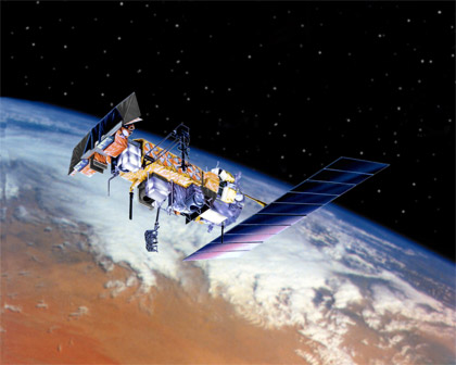
Image Credit: Lockheed Martin | Artist conception of NOAA-N Prime in orbit.
However, a fact largely ignored by many is that nations need to better use the currently available space systems if stakeholders are going to provide persistent and pervasive surveillance of all areas needed to establish Maritime Domain Awareness. Doubtless, users also need the means to process, fuse, analyze, display and disseminate available data, to make accurate decisions and to interdict any suspicious vessel before they enter ports or approach anything of value. But, more information is necessary at the front end of the Detect-Analyze-Decide-Act (DADA) chain for success in most scenarios.
The most promising class of systems for pervasive ocean surveillance is provided by satellites operated by a broad range of U.S., Canadian and other foreign governments and civilian organizations. As indicated earlier, no one system or type of system can do it all. This is true even when considering the most sophisticated space systems. Indeed, at least four basic types of space-based systems need to be used in conjunction with each other. Two of the four employ active sensors and include:
- Synthetic aperture radar satellites (SARSats) and
- Electro Optical (EO) Imaging satellites.
The other two are based on communications systems and include:
- Individual Transponders linked to Communications Satellites (e. g. Iridium, ORBCOMM, etc.) and
- Automatic Identification Systems (AIS) – a system originally designed for collision avoidance and navigation safety but which is now being used as a primary ship tracking system.
It is important to consider these four types of satellite systems. The Canadian government currently operates two SARSats in a public-private partnership with McDonald, Dettwiler & Associates. It launched the first one in 1996, and it has been sufficiently successful that a much more capable system, RADARSAT 2, was launched in late 2007. Canada is expected to launch an additional three to six radar-equipped satellites within the next decade. These systems operate in five basic modes and at low resolution have very wide sensor swaths. Most, if not all, of the forthcoming three to six SARSats will be equipped with AIS receivers. Germany, Italy, India, Japan and Israel have all launched radar satellites, and several other countries are moving in that direction as well. SAR sensors can see through cloud cover and detect vessels and their wakes day or night. Software has been developed to exploit the products from a range of different satellite types, both SAR and optical. While only about 10 truly civilian SAR systems currently exist in orbit today, several companies/countries plan to add more.
The next types of systems – EO satellites – are also operated by a number of countries and companies. Their capabilities have expanded to the point where even a layman can look at an image and immediately recognize a specific building and, in many cases, tell which types of cars (trucks, sedans, convertibles, etc.) are parked in its lots.
The third type of satellite are the communications transponder systems, such as those carried on InMarSat, Iridium, Global Star, ORBCOMM and other communications satellites. Fishing vessel owners and other types of highly mobile platforms employ these systems to maintain active track of their assets for a variety of reasons. For example, fishing vessels must be able to prove they did not go into restricted waters. Tugboat companies need to be able to track their assets on a near hourly basis for business purposes. Many other companies employ these self-reporting systems for other valid business, security and/or safety reasons.
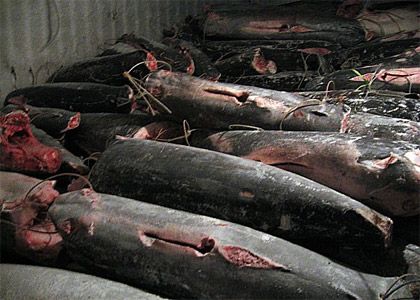
U.S. Coast Guard photo | Stacks of fish lay in the hold of the Taiwanese-flagged fishing vessel Yu Feng as a result of alleged illegal fishing activity off the coast of Freetown, Sierra Leone.
The fourth type is a new type of space-based system. The International Maritime Organization (IMO) and the International Association of Marine Aids to Navigation and Lighthouse Authorities (IALA) designed the Automatic Identification System (AIS) as a collision avoidance and traffic management system. AIS is now a universal requirement for all commercial vessels more than 300 tons (about 100 ft.) and all vessels carrying passengers. AIS automatically provides the names, course, speed, size, depth and other information items to all similarly equipped vessels within line-of-sight of their vessel. In October 2001 the author of this article recognized that if AIS could be collected from space it would revolutionize how ships were tracked worldwide. After a number of false starts, the author was able to get the United States Coast Guard to fund development of a very capable AIS collector onboard an ORBCOMM communications satellite. On June 19, 2008, the company launched that satellite and considered the idea so compelling that it launched five more of its own at the same time. It has announced plans to launch at least 21 more. Several companies and countries have also launched AIS collectors. COMDEV of Canada also quickly recognized the potential of space-based AIS and has now created a spin-off company, exactEarth, to develop and market a constellation of its own AIS collectors. Several other countries and companies are also planning to launch more. Thus, a growing capability exists, which will only increase, to track the ship safety and identification beacon on a worldwide scale. The initial results of these efforts are very promising.
On the Ground Developments
What to do with all of this data? Canada, for one, has developed its own ship-detection software called “OceanSuite,” and the various satellite processors have been designed to complement each other to optimize ship-detection performance. The European community is also working to leverage their resources. The four-satellite COSMOS SKYMED SAR constellation will be part of the future MUSIS (Multinational Space-based Imaging System), which will combine the resources and space assets of Italy, Belgium, Greece, Germany, France and Spain while other European countries could still join. The rest of the space-faring world has taken note and discussions are underway in a number of locales.
The United States has also been active in this area. A large player in the area of U.S. civilian space for Maritime Awareness is the Center for Southeastern Tropical Advanced Remote Sensing (CSTARS) at the University of Miami. The University, in cooperation with Vexcel Corp. of Boulder, Colo., developed “OceanView™,” a software program allowing for rapid analysis of any commercial imaging system to determine if vessels were imaged. It can generally tell the size, type, course and speed of the vessel imaged from most civilian space-borne sensors. Several organizations are working to improve processing of the images. These organizations hope to gain additional access points by establishing mobile downlink sites in new places. This is important because timeliness of reporting is dictated by the time between recognizing the need to collect data in a specific area, the tasking of the satellite, the collection of data by satellite and its down-link to an earth station for processing and reporting. Downlink sites in places like the Indian Ocean, South America, East Asia and other locations across the world allow for wider collection opportunities and timelier reporting, which are a requirement for a truly worldwide system. A global consortium of nations would make this an easier problem to solve.
Although no one system can do it all, a judicious mix of the above systems should allow partner nations to detect, identify, track and interdict nearly all vessels approaching their coasts. Indeed, no silver bullet exists, but some effective copper and silicon ones, and space systems are the key. Stakeholders just need to collaborate on an international scale in order to realize their potential.
International communities in both global maritime and space segments already cooperate with each other in many ways. The international space station launched in 1998, and still going strong, is a major case in point. Another is IALA and IMO. C-SIGMA proposes that international maritime and space communities take the next step, which is to set in motion the process needed both to build broad agreement and to establish an international body to manage, construct and run a Global Space Partnership
U.S Coast Guard Science and Technology Advisor
george.g.thomas@uscg.dhs.govGlobal Challenges