


The Florida Everglades: Rescuing an Endangered Ecosystem
Fifty percent of one of the world’s irreplaceable gems has disappeared and the other 50 percent is dying, both the result of human development. The Everglades, a UNESCO World Heritage Site and International Biosphere Reserve in South Florida, is the victim of man-made changes to improve upon Nature for the benefit of mankind. The primary culprits who authorized and implemented what began as an effort to totally and artificially manage the water resources of the Everglades were Congress, the State of Florida and the U.S. Army Corps of Engineers (USACE). Today, these same agents are the backbone of the largest and most expensive ecosystem restoration program in the world, the Comprehensive Everglades Restoration Plan (CERP), which is designed to restore the South Florida ecosystem. The Plan “includes restoring natural flows of water, water quality and more natural hydro-periods within the remaining natural areas” and is “intended to result in a sustainable South Florida.” This 35-year project was estimated in 1999 to cost $7.8 billion under a 50/50 federal-state cost-share, with an additional $182 million needed annually to operate, maintain and monitor the plan.
According to the United Nations Education, Scientific and Cultural Organization (UNESCO), the Everglades “contain the largest mangrove ecosystem in the Western Hemisphere, the largest continuous stand of sawgrass prairie and the most significant breeding ground for wading birds in North America. Its mixture of subtropical and temperate wildlife species is found nowhere else in the United States.” The exceptional variety of the Everglades’ water habitats has made it a sanctuary, providing refuge for more than 800 species of land and water vertebrates that include 20 rare, endangered and threatened species, such as the Florida panther, snail kite, alligator, crocodile, manatee, two swallowtail butterfly species and the indigo snake. In addition, Everglades National Park “is rich in both prehistoric and historic heritage,” containing 200 known archeological sites. The Everglades subtropical wetlands were originally a web of marshes and prairies 4,000 square miles in size.
The U.S. Army Corps of Engineers maintains that “if we do not act now, irretrievable loss of this extraordinary resource will occur. The remaining Everglades no longer exhibit the functions and richness that defined the pre-drainage ecosystem. There has been a substantial reduction in the size of the Everglades. Total water storage, timing, flow patterns and water quality within the Greater Everglades ecosystem have been substantially altered.
“The Comprehensive Plan is intended to reverse the course of the declining health of the ecosystem. It is important to understand that the ‘restored’ Everglades of the future will be different from any version of the Everglades that has existed in the past. Due to the irreversible physical changes that have occurred in the ecosystem, the restored Everglades will be smaller and somewhat differently arranged than the historic ecosystem.

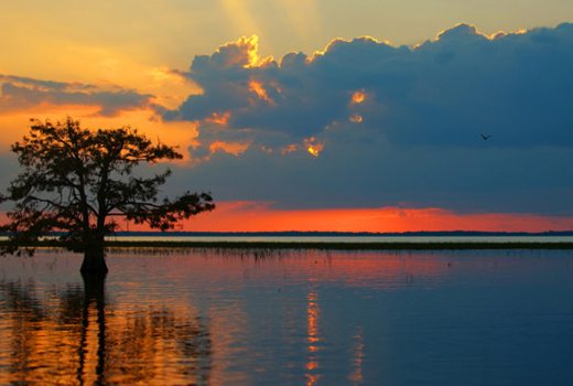
Photo by Susan Schermer
“With the restoration of the hydrological and biological patterns, which defined the original Everglades and which made it unique among the world’s wetland systems, this successfully restored ecosystem will once again exhibit the richness of biological diversity of the former Everglades.”
The South Florida Water Management District has identified specific indicators of the Everglades’ current ecosystem problems, which include:
- 90 to 95 percent reduction in wading bird populations, with 68 plant and animal species threatened or endangered;
- 1.7 billion gallons of water per day on average lost through discharge to the ocean;
- 1 million acres of the ecosystem under health advisories for mercury contamination and more than 1.5 million acres infested with invasive, exotic plants;
- declining population levels of commercially and recreationally important fish species in the St. Lucie and Caloosahatchee estuaries and Biscayne and Florida Bays;
- defoliation of seagrasses, fish kills and deformed fish within the St. Lucie estuary;
- continued reduction in number of birds initiating breeding in South Florida and
- repetitive water shortages and salt water intrusion.
Draining the Everglades
According to Stu Appelbaum, former Chief, Planning and Policy Division at USACE’s Jacksonville, Fla. District and head of CERP, “There’s a long and not always good history of water resources management in South Florida, which really begins with Florida becoming a state in 1845. It wanted to drain the Everglades not only because of its perceived inhospitableness but also because of the rich peat soil that underlay the land. The notion was, ‘Boy, if we could just drain those soils, we could have really rich, productive farmland.’ Many of the lands that made up Florida were wetlands, and they were turned over by the federal government to Florida in 1850 with the stipulation they be drained, cultivated and turned into productive use.”
Hamilton Disston, a real estate developer who purchased four million South Florida acres for $1 million in the late 1800s, dredged and channelized the Kissimmee River, and he also connected the Caloosahatchee River to Lake Okeechobee because the latter has no natural outlet. Water would move down from the Chain of Lakes, the headwaters of the Florida Everglades just south of Orlando, into the Kissimmee River and then Lake Okeechobee.

Source: www.evergladesplan.org
Lake Okeechobee would fill up and periodically overflow its south rim. That water would move through the Everglades down into Florida Bay – a distance of about 100 miles from Lake Okeechobee, with a change in elevation of only 20 feet, and roughly 40 to 60 miles wide.
The second “era” of water resources management occurred from 1905 to 1928 when then Florida governor Napoleon Bonaparte Broward created the Everglades Drainage District. “He did a pretty thorough job of trying to drain the Everglades,” comments Appelbaum, “as he created the St. Lucie Canal, which provided an East Coast outlet from Lake Okeechobee to the ocean. Broward also created the four main agricultural canals that exist today – West Palm Beach, Hillsborough, North New River and Miami Canals.”
However, from 1926 to 1928 a series of hurricanes hit South Florida and killed approximately 2,500 people, thus causing catastrophic damage. In 1930 the U.S. Army Corps of Engineers was authorized to construct what is today the Herbert Hoover Dike around the waters of Lake Okeechobee. This was the first major Corps involvement in flood control in South Florida. Ironically, in the 1930s major fires also occurred in the Everglades because the Everglades Drainage District worked too well. In the dry period, they over-drained the Everglades. But in 1947, South Florida was underwater for months at a time due to a very wet year, which included two hurricanes. At this point, the State of Florida conceded that it had a problem and asked for help. This resulted in the Corps of Engineers putting a plan together called the “Central and Southern Florida Project (C&SF Project),” which was first authorized by Congress in 1948.
All canals in South Florida created as part of this “massive system of plumbing” are the result of this authorization, which extends from the Kissimmee down to Florida Bay and includes Herbert Hoover Dike and Disney World in the ecosystem. The Corps took the Kissimmee, a 103-mile long river, and converted it into a 56-mile long, fairly straight canal. It has been a managed system to some degree since it started being drained back in the 1880s, but it became a more comprehensively managed system with construction of the C&SF Project. The latter was built in a 25-year period, which began in the 1950s and ended about 1975.
“Everglades National Park (ENP) is at the southern end of the system,” explains Appelbaum, “and depends on the C&SF Project for water coming into the Park. That’s one of the issues. USACE has been mandated by law since 1968 to supply water on a monthly schedule into ENP. That was based on a concern that they weren’t getting the water they needed. They want a more natural regime, but one of the complexities of restoration is that we, obviously, can’t put Florida back the way it was 150 years ago. So, it’s always going to be a managed system. The question is, ‘Can we restore and recover the essential characteristics of the Everglades?’ The answer for me is ‘yes.’
“Although ENP represents only about 20 percent of the historic ecosystem, it’s the poster child, and most people associate the Everglades with it. In fact, we’ve lost about 50 percent of the spatial extent of the Everglades to development on the Florida East Coast from West Palm Beach down to Homestead and to agriculture from the Everglades Agricultural Area and to Disney World from the headwaters in Kissimmee. And, frankly, we’re not getting that back. So, the real question is, ‘What can we do from a restoration standpoint to try to recover the function?’
“The bottom line is that the C&SF Project did wonderful things. It made it possible for seven million people to live in South Florida. It did everything it was advertised to do, but it had unintended consequences on the natural system. In fact, the major factor in the degradation of the ecosystem is clearly the C&SF Project.”
Valuing Ecosystem Services
The first ecosystem restoration project is occurring in the headwaters of the Kissimmee. The Corps is not able to restore the entire 103-mile long river, but approximately 20 miles of the middle section will be restored.
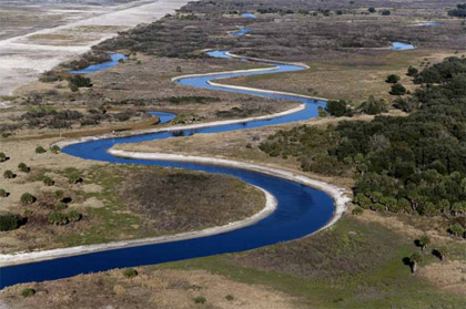
Photo by Mark Bias|The Corps backfilled the C-38 canal (upper left) and re-carved
and connected a meandering Kissimmee River.
Appelbaum says they are removing “about 22 miles of the canal out of the 56 miles we created. We’re supposed to complete that project at the end of calendar year 2014, so we’re getting to the finishing touches. We have two major contracts left to backfill the canal, and the results to this point – we’re probably 65 to 75 percent done – have been fantastic. What we’ve done is reconnect the remnant river sections that were out there and backfill the canal itself to get rid of it. Then we went back to the old meandering river and the interaction between river and floodplain. Even from the air, you can barely tell where the canal used to be. We didn’t even reseed it or anything. Once we put the physical form back, there’s so much seed stock out there that Nature just takes care of the rest.
“The Corps justified the project on improvements to habitat – on the environmental value. There’s a whole movement now to try to put a value on ecosystems, called ‘Ecosystem Services.’ It’s kind of in its infancy, but there are serious attempts to try to monetize as best we can, or at least try to categorize, services an ecosystem provides to humans either directly or indirectly.”
According to a USACE Factsheet, “the Kissimmee River Restoration dates to 1992 when the U.S. Congress authorized this joint state-federal project. When restoration is complete, more than 40 square miles of river-floodplain ecosystem will be restored, including almost 20,000 acres of wetlands and 44 miles of historic river channel. About 98 percent of land needed to complete Kissimmee River Restoration has been acquired – a total of 102, 061 acres.
“Environmental Results. The river and its floodplain have improved in remarkable ways, thus surpassing at times the anticipated environmental response. Comprehensive monitoring for the past five years has documented these results. Improvements are compared with conditions existing prior to restoration.
- Wetland plants are thriving in the floodplain, including pickerelweed, arrowhead, Carolina willow and buttonbush.
- Undesirable floating and mat-forming plants have been replaced by emergent plants native to the historic river.
- Organic deposits on the river bottom decreased by 71 percent, thus reestablishing sand bars and providing new habitat for shorebirds and invertebrates, including native clams.
- Dissolved oxygen, which is critical for the long-term survival of fish and other aquatic organisms, has increased up to six-fold.
- Largemouth bass and sunfish now comprise 63 percent of the fish community; prior to restoration, they represented only 38 percent.
- Long-legged wading bird populations, including white ibis, great egret, snowy egret and little blue heron, have increased significantly, in some years increasing at greater than double the restoration expectation.
- Ducks have returned to the river, including American widgeon, northern pintail, northern shoveler, ring-necked duck and black-bellied whistling duck.
- Eight shorebird species, absent before restoration, have returned to the river and floodplain, including breeding black-necked stilts.”
Creating CERP
In 1993 Appelbaum was tasked to put what would become CERP together. He decided to “do the project very differently, so we put an interdisciplinary interagency team together, which included other federal and state agencies.
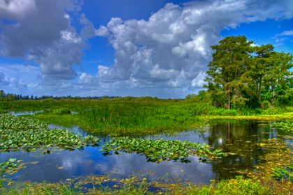
© iStockphoto.com/johnandersonphoto
“We wanted to think out-of-the-box and also have very integrated public involvement. Up to that point public involvement in the Corps traditionally meant holding a public meeting before we put a draft report out. I fought hard to get outreach and public involvement integrated into the project up front. I wanted us always thinking about the outreach – how to communicate and get input from the public, and how to communicate the message. We held a series of nine public meetings with a workshop format over about a 2-1/2 week period within the problem identification phase, which was pretty grueling. I think this was very cutting-edge for the Corps at the time. The public involvement was not only a major part of the study; it was actually integrated into the study. The outreach person sat at the table with the rest of the study team, so there was this constant give and take between all team members.
“Putting the best plan in the world together that’s not implementable is the same thing as doing nothing. And, I wasn’t interested in just doing an academic study, so it had to be implementable at the end. We had a couple of wonderful institutional mechanisms along the way. One was the formation of what is today called the ‘South Florida Ecosystem Restoration Task Force,’ which was codified in 1996 but which began in 1993. The mission of this Task Force enlarged greatly, but the point at the beginning was to at least get the federal agencies to speak in a common language and to have a common vision. This was at a senior, sub-cabinet, assistant secretary level and corresponding types of state people. So, it was at a very high policy level.
“The second fortuitous event was the formation of the Governor’s Commission for a Sustainable South Florida, which was formed by Governor Chiles in 1994. Essentially, we were doing the initial reconnaissance phase on the Everglades. The effort was called the ‘Restudy’ – The Central and South Florida Comprehensive Review Study – which was the restudy of the C&SF Project. There was a lot of nervousness in Tallahassee because this was going on and that it was Corps-led. Agencies were involved, but there wasn’t a forum for stakeholders and NGOs to play in, particularly with the federal government and our restrictions under the Federal Advisory Committee Act. Governor Chiles was smart enough to put this Governor’s Commission together primarily to look at water and sustainable issues in South Florida with particular emphasis on this Restudy effort. As a result, we worked very closely with the Governor’s Commission from 1994 to the completion of the plan in 1999 to basically understand what stakeholders wanted and then to work the technical issues. When the plan went forward to Congress in 1999, there was absolute consensus among the stakeholders that this was the right plan.
“The Plan was approved in the Water Resources Development Act of 2000. We’re in the early stages of implementation. The Plan is a whole, but it’s being implemented as separable projects, so just keeping the program together with the projects and how things fit together to set-up implementation is quite a challenge.
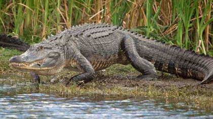
Photo Credit: Sout Florida Water Management District
“Programmatic regulations, which is federal rule-making, were required, so the whole process for this program – how it operates, the relationship among the parties, how the projects fit with the program, how we monitor progress, how we do adaptive management – all these things are codified in federal rule-making. I led the development of that, and it was pretty challenging from a policy standpoint. Implementing this required concurrence from the Department of the Interior (DOI) and Governor of Florida. You can imagine trying to get the Corps, State of Florida and DOI all lined-up and in concurrence with these regulations. That was quite a challenge. It took us three years to draft those regulations. The legislation came out at the end of 2000, and it took us until the end of 2003 to actually implement that.
“The thing that makes this all work is the science. Yes, it’s challenging from an engineering standpoint. There’s inevitable tension between scientists, engineers and others, but it’s a scientifically driven program. I think that’s one of the reasons it has enjoyed the support it has politically as well as from stakeholders. We also pay attention to this notion of adaptive management. Ecosystem restoration is not as mature as flood control and navigation, so you get in this conundrum of do you wait – there’s a lot of scientific uncertainty out there – until you have all the answers? If you do, you’d be doing a post-mortem on the Everglades, so we’re not interested in that. Without absolute certainty, there’s a lot of risk, but you adapt the projects as necessary if you find they’re not meeting goals. We put adaptive management into the plan, and Congress actually said, ‘This is the way you need to go.’ Waiting to get all the answers gets you paralysis by analysis.
“It was always envisioned this would be a long-term project. One of the reasons we do a lot of outreach – in schools and everywhere else – is because this is a multi-generational endeavor. The kids in school today are going to be the taxpayers having to make decisions on implementation before this is over with. The project is so large that it’s going to take us 35 years to complete. It’s taken us more than one hundred years to screw-up the Everglades; it’s not unreasonable to take 35 years to at least recover what we can. By project’s end, we’re going to make a healthy Everglades.”

Photo Credit: U.S. Army Corps of Engineers|Stu Appelbaum (left), Vice President Joe Biden and Maj. Gen. Todd Semonite
Stuart J. Appelbaum retired from the Jacksonville District May 3, 2012. He was responsible for developing and administering the Jacksonville District’s water resources planning in the State of Florida, Commonwealth of Puerto Rico and the U.S. Virgin Islands. He was also responsible for working with Corps higher authority and sponsors to frame and resolve policy issues that affect execution of the Jacksonville District’s program. Appelbaum previously served as Chief of the Everglades Division from 2007 to 2011 with responsibility for overseeing the south Florida Everglades ecosystem restoration program. He also previously served as Chief of the Planning Division from 2005 to 2007. He was chief of the Ecosystem Restoration Branch in the Jacksonville District and was responsible for leading the team that developed the comprehensive plan to restore the Everglades that was authorized by Congress December 2000. Appelbaum was also responsible for developing the programmatic regulations that guide implementation of the restoration plan. He has received a number of awards for his work on the Everglades restoration including the Palladium Medal, a joint award from the American Academy of Engineering Societies and the National Audubon Society, and a special achievement award from the Everglades Coalition. Appelbaum has a B.S. in Civil Engineering from the Polytechnic Institute of New York and a M.S. in Water Resources Engineering from George Washington University. He has taken a new position with ARCADIS beginning May 7, 2012, as head of the Water Division’s integrated water planning group.
For more information on the Comprehensive Everglades Restoration Plan (CERP) – The Journey to Restore America’s Everglades – go to www.evergladesplan.org. This exciting program is a partnership of the U.S. Army Corps of Engineers, South Florida Water Management District and many other federal, state, local and tribal partners.
Global Challenges