


U.S. Air Force Managing Wetlands at Hurlburt Field
Scientific research estimates that more than one-half of U.S. wetlands have been drained, dredged, flooded or filled since the beginning of colonial America with 45 percent of this loss due to urban development (NOAA, 2004). These numbers were documented following passage of the 1972 Clean Water Act (Federal Water Pollution Control Act, Public Law 92-500) when other regulations were being set-in-motion to protect this natural resource. Despite an increase in public awareness of wetland benefits, continued loss has resulted in tighter regulatory review of projects impacting wetlands and a detailed scrutiny of mitigation measures that attempt to compensate for its degradation.
For military installations, such as Hurlburt Field, Fla., (read more about Hurlburt Field in the May 2012 livebetter article, USAF’s Hurlburt Field: Black Bear Management Challenges) where wetlands account for more than one-half the land area, decision-makers need to be creative to sustain landscapes necessary for military readiness. In addition, they also need to ensure that a “best-fit” throughout the life of facilities and infrastructure is achieved for the mission and the natural environment. Limited and costly mitigation options often combine with funding accessibility issues and complexities of project planning to present almost insurmountable challenges. Early planning, education, resource awareness and solid partnering play an integral role in preparation when the requirement is at hand.
Background: Wetland Regulations
In 1972, Section 404 of the Clean Water Act (CWA) placed the Environmental Protection Agency (EPA) and the U.S. Army Corps of Engineers (USACE), along with state agencies, in control of restoring and maintaining the chemical, physical and biological integrity of the Nation’s waters. Section 401 places authority in the hands of the state or regional agency to regulate any proposed federally permitted activity that may impact jurisdictional waters or wetlands. In addition to CWA, the Department of Defense (DOD) and its military agencies are required to review all environmental impacts, including wetlands, under the National Environmental Policy Act (NEPA-42 U.S.C. s/s 4321 et seq. 1969).
U.S. Air Force Photo
The 1977 Executive Order 11990, Protection of Wetlands, provides subsequent guidance for federal lands by requiring decision-makers to consider alternate locations for proposed activities in order to minimize or to avoid wetland impacts. Therefore, each installation’s commander must evaluate and certify whether a project sited in a wetland provides the best and most cost-effective solution that will meet the requirements while also resulting in the least adverse impact. This “Finding of No Practicable Alternative” ultimately joins the final record of decision produced by an Environmental Assessment (EA) in accordance with NEPA.
Less than a decade later, as wetland losses continued to spiral, Congress was prompted to adopt a “no net loss” policy and a specific mitigation sequence was outlined as follows: Avoid, Minimize and Compensate. Investigations by the National Research Council (NRC) in the late 1990s revealed that many compensatory mitigation projects were not being monitored and created wetlands were not consistently achieving mitigation goals outlined in the permit (National Research Council, 2001). As a result, the regulatory arena responded with demands for strict review of siting alternatives, refinement of functional values by which wetlands were measured, perpetual monitoring of mitigation sites and a solid financial commitment to assure these tasks were performed.
Constraints on the Mission
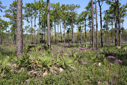
Hurlburt Field spans more than 6,634 acres in Northwest Florida. Fifty-two percent of the land area is wetlands and only 33 noncontiguous, buildable acres remain free of constraints. The Base is sandwiched between the vast East River swamp to its north and the intercoastal waterway to the south, setting the stage for pristine habitat, which supports many rare species of plants, animals and the federally endangered Flatwoods Salamander (Ambystoma bishopi ). In just the last two years, 22 projects totaling more than 1,000 acres of wetlands have been subject to some sort of permitting action authorizing routine maintenance, dredge and fill and enhancement activities. A recent wetland delineation survey used 8,000 boundary flags to map approximately 100 miles of wetland line. That project is not yet finalized and is approaching a two-year period of performance.
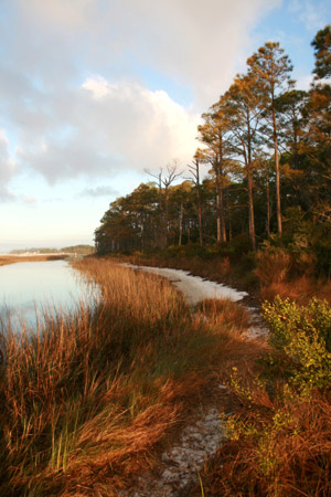
U.S. Air Force Photo|The salt marsh created along the shoreline of Hurlburt Field.
It is safe to say that Hurlburt Field planners and natural resources managers have a good understanding of how wetland restrictions can complicate mission requirements. The Base is also no stranger to mitigation, having been successful in the mid-90s with creation of a salt marsh to compensate for construction in airfield wetlands. The year 2000 brought closure for three years of innovative strategies by Base environmental leaders to coordinate permits and to propose satisfactory mitigation for seven different military construction projects. A single 10-year permit, issued by the Florida Dept. of Environmental Protection (FDEP) and the U.S. Army Corps of Engineers (USACE), authorized construction of all seven projects, which would ultimately fill more than 29 acres of wetlands on the installation.
The approved mitigation plan placed approximately 3,000 acres of Base wetlands and uplands into preservation, called for 125 acres of longleaf pine restoration, 4.3 acres of salt marsh creation and implementation of a detailed land management plan, i.e., prescribed fire, invasive species management. The Base also entered into a Memorandum of Agreement (MOA) with the FDEP, which promises to protect these mitigation areas from any form of future development or human disturbance in perpetuity. The 10-year permit has now expired.
Balancing mission growth and remaining compliance with tougher regulations can be a challenge for even the most experienced. Constraints not only include physical land restrictions but also limitations imposed by requirements for protection of species and habitat. Funding constraints become prohibitive as mitigation and long-term monitoring costs result in a daunting financial and management burden.
Where to Begin: Putting a Price on a Wetland
Wetlands are recognized as a unique ecosystem set apart from all others by characteristic soils and vegetation suited to saturated conditions at some time during the year. Wetlands serve as important breeding grounds for many rare species of flora and fauna and play a vital role in maintaining biodiversity in the landscape. Marine and wildlife habitat, water quality, public health and the economy are all influenced by wetlands. However, wetlands can be of varying importance to society depending on its role in the community and its function in the landscape, i.e., food source, recreational opportunities, natural barrier against flood waters, critical habitat, effective pollutant filtering system (Gren et al., ’94).
These values can be quantified for both credits (mitigation) and debits (impacts) by using a functional assessment method. In Florida, the Uniform Mitigation Assessment Method (UMAM) is the method used by both FDEP and USACE to evaluate wetland functions. UMAM evaluates wetland function from three categories: location and landscape, hydrology or water resources, and community or ecological structure. The method allows the evaluator to rank the current condition of the wetland and also its condition “with impact” on a scale of one to 10 for each category. UMAM takes into account factors like risk and time lag that may affect the success calculating the number of mitigation acres required. View a table of scores calculated to meet state and federal requirements.
# Mitigation Acres = (Functional Loss*Impact Area) – (Relative Functional Gain*Mitigation Area)
Next Steps: Compensatory Mitigation Options
The Army Corps of Engineers defines mitigation as “the restoration, creation, enhancement or preservation of wetlands when compensating for natural wetland loss.” Not all projects require mitigation, but when it is determined that compensatory offsets are necessary, either of these methods can be used.
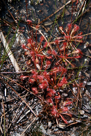
U.S. Air Force Photo | Sundew Plant at Hurlburt Field
A wetland functional assessment of both the impact and mitigation site along with other permitting documents is reviewed by the approved regulatory authority to determine if the proposed mitigation is sufficient. A complete mitigation plan must address attainable goals and provide an ecological baseline report, a work plan, maintenance plan, performance standards and financial assurance. Assuring “no net loss” is not an easy task. Therefore, preservation in the form of mitigation banking credits has become the preferred option for landowners and regulators.
Mitigation banks are usually wetland areas that have been established or restored specifically for the purpose of providing compensation for wetland impacts. Scientific studies have shown that created wetlands do not typically develop the hydrogeomorphic properties of natural wetlands and many times fall short of functional goals. The same is true for enhancement or restoration projects, which require long-term monitoring and generally do not achieve the required ecological “lift” or offset. Mitigation banks must conform to state and federal regulations before credits become available for sale. And, because credits can be purchased from the bank for a pre-determined price, the permittee is offered a finite, guaranteed mitigation option.
In recent years, a deeper understanding of location-related success for wetland mitigation projects has been gained. Investigations by NRC (2001) and others concluded that wetland mitigation must be approached from a watershed level in order to successfully re-create wetland environments (Russell et al. 1997 and Van Lonkhuyzen et al 2004). Therefore, siting mitigation projects away from the impact site but within the same watershed is important for sustaining better water quality and flood control at a landscape scale. In 2008, federal standards for mitigation banking were developed: 1.) units of trade, bank credits, are measured by the gain/loss of wetland function, 2.) like credits must be used in exchange, 3.) the mitigation bank must be in the same watershed or service area as the impact, 4.) number of credits are determined by an approved assessment method.
Planning for Construction in a Wetland
Project planning can be especially difficult when wetland impacts are considered. Time-tables for meeting design deadlines, obtaining funding and securing mitigation options are consistently out of sync. Soon after the proponent initiates a request for new construction, the project is sited by the community planner. Project costs, including funding for the EA and compensatory mitigation, are estimated and programmed. At this point in the process, a mitigation plan has not been developed nor has a functional assessment been performed. The cost of a 1:1 ratio of bank credits to acres of wetland impact may be used to estimate mitigation costs. But, unless environmental managers can be confident of mitigation options, it can be far from accurate.
NEPA law states that environmental review must be concluded before government funds are committed. Hence, the entire process can be brought to a stalemate when insufficient design information is provided for environmental review. Additionally, it is important to note that the EA could yield a significant adverse impact determination or be subject to lengthy legal reviews. It is only after an EA is complete and mitigation plans are finalized that construction engineers may be able to move forward with permitting documents.
Hurlburt Field Case Study
The ground-breaking for a new supply warehouse on Hurlburt Field began July, 2011. An EA and full review under NEPA determined that the construction location, which impacted 6.5 acres of forested wetland, was the preferred site to meet all requirements. Project planning began in 2008 when no apparent mitigation options were available. The one mitigation bank in the service area offered only herbaceous wetland credits as opposed to Hurlburt’s forested requirement. No possible sites existed for creation or restoration on Hurlburt and options in the watershed were limited, except for potential opportunities located on the adjacent Eglin Air Force Base. Initial meetings with the Range Configuration Control Committee highlighted the win-win solution for both bases. A project was identified to offer the ecological lift needed to offset Hurlburt’s impacts while providing much needed rehabilitation to endangered species habitat at Eglin.

Photo Credit: Kelly Jones, Virginia Tech, Eglin Air Force Base
|An adult Flatwoods Salamander found during a recent survey at Eglin Air Force Base.
The Flatwoods Salamander (Ambystoma bishopi ) lives and breeds in wet pine flatwoods and has been on the Endangered Species list since 1999. The species is native only to small areas in Northwest Florida, specifically Eglin and Hurlburt. Due to fire suppression and drought, the ponds had become overgrown. The dense tree canopy blocked sunlight necessary for the growth of herbaceous vegetation essential to the salamander’s survival. The project drew welcomed feedback from subject matter experts representing 12 different agencies, i.e., The Nature Conservancy, University of Florida, Fish and Wildlife Service, U.S. Division of Forestry and Florida Natural Areas Inventory. At the programming stage, rehab of the ponds to include clearing, herbicide, fire and monitoring was proposed as mitigation, and the cost was conservatively estimated on the purchase of seven bank credits (one for each acre) at $90K each.
UMAM qualitative and quantitative functional assessment worksheets were completed by Hurlburt environmental staff for each of the 11 breeding ponds as well as for the impact site. A functional assessment scoring matrix provided regulators a detailed look at quantitative calculations performed on the relative functional gain that each pond provided. USACE and FDEP required different risk factors, which resulted in two mitigation scores for each pond. A matrix was also developed to relate pond vegetation communities to established classifications, such as the National Wetland Inventory. When the state permit was finally issued in late December 2010, restoration of 35 acres of salamander habitat had been approved as mitigation. The USACE permit followed within the next few months. The entire process encompassed many hours of field verification, pre-application meetings, multiple revisions of the mitigation plan and more than three years to complete.
Future Planning: Protecting the Investment
Hurlburt can share many lessons learned from this case study:
- Maintain good relationships with regulators;
- Investigate creative partnerships and management agreements in your watershed;
- Understand the permitting process and requirements;
- Be aware of mitigation banks in your service area and be familiar with pricing and availability of credits;
- Educate base contracting about Clean Water Act requirements.
In 2011, Hurlburt Field was successful in purchasing mitigation credits in advance and exclusive of a permit – a first for the Air Force. Prior to the purchase, regulatory input was sought to determine if these credits could be used to offset future wetland impacts. Environmental managers assisted base contracting specialists to complete legal requirements and work through a very non-standard funding requirement at the final hour of fiscal year-end. Hurlburt also prepares for future impacts by working closely with community planners, quality assurance engineers and contractors.
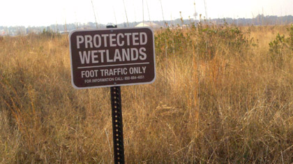
Unauthorized impacts are regularly avoided by maintaining a binding jurisdictional wetland survey. These surveys can be expensive, but they help to minimize overall costs and time on a project-by-project basis. Staff educated on best management practices routinely monitor construction projects to ensure silt fences and hay bales are properly installed. Contractors are encouraged to boldly mark wetland lines on construction drawings and to flag wetland boundaries prior to work being performed in the field. Signs placed near wetland boundaries also alert nearby workers of sensitive areas. These steps can protect not only wetlands but habitat as well.
As stewards of wetlands on more than 25 million acres of land across the country, the DOD is committed to sustainable development through application of environmental principles in all aspects of military readiness. But, while demands on sensitive land resources increase, it is vital that decision-makers understand the options available to them so management strategies can be optimized to balance biodiversity conservation with defense objectives.
U.S. Air Force Photo
Natural/Cultural Resources Program Manager, Hurlburt Field, U.S. Air Force
Kristal.walsh.ctr@hurlburt.af.milGlobal Challenges